By Emilia Wellesley · Published May 6, 2026 · Updated May 13, 2026
What Is the Derinkuyu Underground City?
Derinkuyu is a multi-level subterranean city carved into the soft volcanic tuff of central Cappadocia, in present-day Nevsehir Province, Turkey. Excavated portions reach roughly 60 to 85 meters below the surface, with about eight cleaned levels open to visitors and additional chambers still surveyed by archaeologists. Population estimates suggest it could shelter as many as twenty thousand people with their livestock and stores.
A handful of places quietly outlast the categories tourists try to file them under. Derinkuyu is one of them. From the surface, the modern town is a low huddle of houses on a high windswept plateau where the soil thins to pale stone within a spade’s depth. The interesting story is downward. Cut into that pale stone is a vertical city of stables, cellars, oil presses, refectories, chapels, schoolrooms, sleeping bays, ventilation shafts, and stone doors as round as millstones, carved out of the volcanic tuff that eruptions of Mount Erciyes and Mount Hasan laid down across central Anatolia in deep prehistory. The first time a visitor descends, the air drops a few degrees almost immediately, and the smell shifts to cool damp limestone and the soot of countless extinguished lamps. The walls remember the tools that shaped them.
This guide moves through the rediscovery, the dating debate, the documented architecture, the Byzantine refuge function, and the larger Cappadocian network into which Derinkuyu fits. It is meant to hold the strangeness of the site without flattening the genuine uncertainty that still surrounds its earliest layers, situating Derinkuyu within the broader landscape of historical and archaeological mysteries.
The 1963 Rediscovery
The story most people first hear about Derinkuyu begins not with an excavation report but with a basement wall. In 1963, a resident of the town renovating a house in the rock-cut neighborhood took a sledgehammer to a passage he could not account for, opened a small cavity behind it, and walked into a tunnel that did not stop where any of his neighbors expected it to, according to the consolidated entry maintained on the site [1]. The local detail that has accreted around the story, as told by Cappadocian guides and reported in a widely circulated Atlas Obscura account, is that he had been losing chickens through a crack the renovation had widened, and the birds were vanishing into something he could not see [2]. Whether the chickens are folklore or fact, the wall is documented. It opened onto a complex sealed off and largely forgotten for roughly forty years.
Why It Was Forgotten
The site had not vanished from memory through accident alone. Cappadocia’s Christian Greek population, the so-called Karamanli, had used Derinkuyu and dozens of similar underground complexes as periodic refuge through the late Ottoman period. After the 1923 population exchange between Greece and Turkey, those communities were resettled and the underground levels were closed up, drifted with dust, and forgotten by their new neighbors within a generation [1]. The 1963 rediscovery is therefore less an unveiling of an ancient secret than the reopening of a working space that had only recently been abandoned. Systematic survey began that same year under the Turkish Department of Culture, and the site opened to organized tourism in 1969.
Why the Story Sticks
The basement-wall anecdote sticks because it does what good archaeological stories do. It locates a vast, anonymous architecture inside a single domestic moment. One man, one wall, one tool. The historian’s instinct is to be careful here. Most popular accounts now report the discovery as if a single Turkish homeowner casually opened the world’s largest underground city in an afternoon. The reality is that local knowledge of the tunnels never fully died, and the 1963 work joined a thread rather than starting one.
How Old Is Derinkuyu, and Who Built It?
The dating of Derinkuyu is genuinely hard, and any account naming a single founding people without qualification is overselling the evidence. The underlying problem is that the medium of the city is rock. Stratigraphy, the standard archaeological dating ladder that depends on layered occupation debris, does not work in carved tuff. Pottery and inscriptions in the upper levels can be dated, but those finds reflect later residents rather than original cutters. Tool marks survive but do not return a calendar year. The earliest documented description of underground dwellings in the region comes from Xenophon of Athens (c. 430 BCE-c. 354 BCE), whose Anabasis around 401-400 BCE describes Anatolian villagers living in chambers reached by ladders from a wellhead-like opening, with separate accesses for livestock [1].
The Phrygian Reading
The prevailing reconstruction, accepted by the Turkish Ministry of Culture and Tourism and reflected in standard reference literature, attributes the first phases of cutting at Derinkuyu to the Phrygians, an Indo-European people whose kingdom in central Anatolia flourished in the eighth and seventh centuries BCE [3]. The Phrygians were experienced rock-cut builders, attested in the open-air monumental tombs of the Phrygian Highlands. The argument is largely cultural plausibility plus regional analogy: the Phrygians had the toolkit, the building tradition, and the political reach into Cappadocia to begin a project of this kind, and the broader sequence of upward layering is consistent with iron-age beginnings.
The Hittite Reading
A minority position, repeated in popular treatments more than in technical literature, pushes the foundation back to the Hittite period of roughly 1700-1200 BCE. Supporters point to a small number of Hittite-style finds reported from the wider Cappadocian network, including a lion fragment sometimes mentioned in connection with Derinkuyu’s upper levels [2]. The case is thin. No closed Hittite layer has been reported within Derinkuyu itself, and the fragment is not securely provenanced. The Hittite reading is best treated as a possibility the surviving evidence neither confirms nor cleanly excludes.
The Wider View
A third option, advanced by independent scholars including the prehistorian Mary Settegast (1934-2020), proposes that the earliest galleries reach further back still, into Anatolia’s deep Bronze Age, drawing on a long tradition of carving the soft tuff of the volcanic plateau [4]. This reading is not supported by stratigraphic evidence and remains speculative, but it is honest about how thin the founding record really is. The interpretive frame to keep visible is this: Derinkuyu is not a building with a single dedication date. It is an accreted city carved by hands that worked there over many centuries, and any single attribution simplifies a layered process.
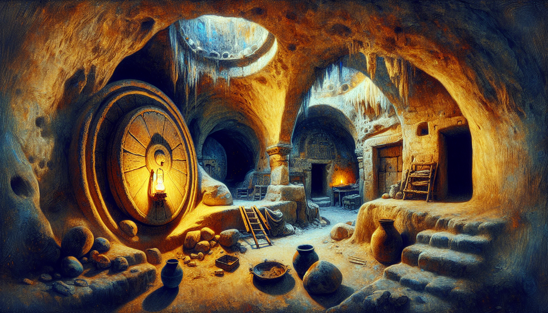
The Architecture in Detail
What the carved chambers themselves preserve is more reliable than any naming of founders. Derinkuyu’s documented depth is approximately 60 meters in the cleared sections and as much as 85 meters in surveyed deeper levels, with roughly eight publicly accessible levels and additional chambers below that have not yet been opened [3]. Popular accounts inflate the level count to as many as eighteen, but the archaeological consensus reported through the Turkish authorities and through scholars working in Cappadocian rock-cut architecture documents about eight clearly cleaned and accessible storeys, with deeper passages whose extent is still under survey [1].
Ventilation and Water
The most elegant feature of the city is its air. A central vertical shaft roughly 55 meters deep functions as a combined ventilation channel and well, drawing air from the surface through the lower levels and supplying water that cannot be poisoned from above. Smaller subsidiary shafts honeycomb the complex, distributing fresh air to the deeper chambers and venting the smoke of cooking fires. The ducts still pull a steady current, and visitors descending the stairs feel a faint draft on their faces well below the highest levels. The arrangement implies engineering competence on the order of months of refuge, not days, and it is one of the strongest arguments for the site’s serious siege function.
Rolling Stone Doors
Each accessible level can be sealed from inside by large circular stone doors shaped like millstones, set in slotted recesses cut into the passage walls. The doors weigh several hundred kilograms apiece. They roll closed across the corridor and lock into a stop, sealable only from the level being defended. A small central hole permits the defenders to observe or to thrust a spear through if attackers attempted to dig the stone out from outside. The doors are the city’s most photographed feature and also one of its clearest signals: this was a refuge designed to hold against an enemy who knew the entrances existed.
Daily Life Spaces
The chambers carry the pattern of long-term habitation. Stables for livestock occupy the uppermost accessible levels, where the smell could vent more easily. Storerooms for grain, oil, and wine sit on the next storey down. Communal kitchens, with carved soot-blackened ovens and grindstones, cluster on the third level. Sleeping bays fill the next two storeys. Deeper still lie chapels, including one with a barrel-vaulted ceiling that may have served as a religious school, and a vertical shaft that functions as a deep cistern. The architecture maps a society that expected, in extremis, to bring everything it cared about underground at once and to wait.
Refuge from the Arab Raids
The clearest documentary use of Derinkuyu lies in the Byzantine middle period, particularly the seventh through tenth centuries CE, when the Cappadocian frontier of the Byzantine Empire was repeatedly raided by Umayyad and then Abbasid forces during the Arab-Byzantine wars [5]. UNESCO’s 1985 inscription of the surrounding cultural landscape, formally titled Goreme National Park and the Rock Sites of Cappadocia, explicitly names the underground cities of Derinkuyu and Kaymakli among the troglodyte settlements that local Christian communities developed under the pressure of these raids [5].
Christian Cappadocia
The Cappadocian Fathers, a group of fourth-century theologians including Basil the Great (c. 330-379), Gregory of Nyssa (c. 335-c. 395), and Gregory of Nazianzus (c. 329-c. 390), gave the region a strongly monastic Christian identity. By the time the Arab raids began, the Cappadocian highlands were dotted with rock-cut churches, monasteries, and underground complexes that locals could retreat into for the duration of a raiding season. Derinkuyu’s chapels, baptistery, and small ecclesiastical schoolroom belong to this Byzantine layer and reflect a community that understood the difference between two weeks underground and two months. The art-historian and archaeologist Veronica Kalas, who surveyed the rock-cut Byzantine settlements at Selime and Yaprakhisar in the nearby Peristrema valley under a Dumbarton Oaks grant, has argued that the underground complexes of Cappadocia should be read as integral to a working Byzantine landscape rather than as desperate hiding places used only in extremis [6].
Connections to Kaymakli
Derinkuyu is connected to its near neighbor, the underground city of Kaymakli, by a tunnel that local accounts and some published surveys place at roughly eight to nine kilometers in length, though the entire passage has not been continuously excavated and travelable [3]. Kaymakli is shallower and broader; Derinkuyu is deeper and more vertical. The pairing suggests a regional defensive logic rather than a single isolated refuge. Surveys directed through the Turkish authorities and summarized in heritage-archaeology reporting have catalogued more than thirty underground cities and over two hundred smaller complexes across Cappadocia, and the network is most plausibly read as a functioning regional system rather than a curiosity of a single town [7].
What Remains Genuinely Open
For all the meters of cleared corridor in modern guidebooks, the founding question of Derinkuyu remains unsettled. Three threads of evidence will need to thicken before any single attribution becomes secure. The first is closed archaeological context within the cut chambers: a hearth, a pottery cluster, or an inscription sealed at a known level by overlying carving rather than by later occupation. The second is comparative dating across the wider network: when Ozkonak, Mazi, Tatlarin, and the smaller complexes are surveyed to a uniform standard, the relative chronology of Derinkuyu against its neighbors will sharpen. The third is documentary: the survival of any Phrygian, Hittite, or early Byzantine reference naming this specific town would change the picture quickly.
How to Hold the Question
The honest stance is the layered one. The Phrygian beginning, the Hittite possibility, the deeper-Anatolian speculation, the Roman-period extensions in some upper chambers, the Byzantine consolidation against Arab raids, the late-medieval Christian Greek use, the 1923 abandonment, and the 1963 rediscovery all sit in sequence. Each layer is differently well attested. The site’s strangeness is not that one of these layers is alien; it is that they have continued for so many centuries to share the same corridors. Underground, the centuries are nearer to each other than they are at the surface.
Reading the City Carefully
Derinkuyu rewards the patient observer. The walls remember the carving rhythm. The shafts still draw air. The stone doors still roll. The chapels smell faintly of damp limestone and lamp soot, the way they smelled to a Byzantine farm family hiding from a raiding party in the eighth century, and to a Karamanli grandmother sealing a door behind her grandchildren in the nineteenth. The caution is to refuse two simplifications: that Derinkuyu is a single ancient marvel built by one mythologized people, or that it is merely late-antique Christian refuge whose deeper origins do not matter. Neither flattening serves the site. It is, more honestly, a layered city in stone whose founding hands left no signature and whose later inhabitants signed by use.
Frequently Asked Questions
Where is Derinkuyu?
Derinkuyu is in central Cappadocia, in modern Nevsehir Province, Turkey, on the Anatolian plateau roughly between the cities of Nevsehir and Nigde. The town and the underground city share the same name; the underground entrance is at the edge of the modern settlement.
How deep is Derinkuyu?
The publicly accessible portion descends approximately 60 meters below the surface, and surveyed chambers reach as much as 85 meters deep. Roughly eight cleaned levels are open; additional levels and corridors lie below and remain closed.
How many levels does Derinkuyu have?
Approximately eight levels are clearly documented and accessible. Popular sources sometimes report eighteen levels, but that figure is not supported by the archaeological survey published through the Turkish authorities. The deeper sections still under study may add to the cleaned total in time.
Who built Derinkuyu?
The standard reconstruction credits the first phases to the Phrygians of the eighth and seventh centuries BCE. A minority view pushes the start back to the Hittite period, roughly 1700-1200 BCE. The strongest documented expansion belongs to the Byzantine middle period, when local Christian communities enlarged the complex as a refuge from Arab raids. No single attribution is secure for the founding layer.
When was Derinkuyu rediscovered?
In 1963, a resident of the town opened a sealed wall during a home renovation and exposed a tunnel into the complex. Local memory of the underground spaces had not been entirely lost, but the systematic clearance and survey of the site began that year, and Derinkuyu opened to organized tourism in 1969.
How many people could Derinkuyu shelter?
Estimates published through the Turkish authorities and major reference works give a refuge capacity of roughly twenty thousand people, together with their livestock and stores. The figure is an upper-bound estimate based on the cubic volume of the cleared chambers and assumed occupancy density rather than a precise demographic count.
What were the rolling stone doors for?
The circular stone doors, weighing several hundred kilograms each, sealed levels of the city from inside. They could only be moved from the side being defended, locking the corridor behind them. A small central hole allowed defenders to observe attackers or to thrust through a weapon if outsiders tried to dig the door out.
How does the ventilation system work?
A central vertical shaft about 55 meters deep functions as a combined air channel and well. It draws fresh surface air down to the deeper levels and supplies water that cannot be reached or poisoned from above. Smaller subsidiary shafts distribute air through the side chambers. The system still pulls a steady draft today.
Is Derinkuyu connected to other underground cities?
Yes. A tunnel of approximately eight to nine kilometers is reported to link Derinkuyu to the underground city of Kaymakli, although the full passage has not been continuously cleared and travelable. Cappadocia contains more than thirty surveyed underground cities and over two hundred smaller complexes, suggesting a regional defensive system rather than isolated refuges.
Is Derinkuyu a UNESCO World Heritage Site?
Yes, indirectly. Derinkuyu is named within the broader 1985 UNESCO inscription titled Goreme National Park and the Rock Sites of Cappadocia, which covers the rock-cut architecture and underground cities of the region. The inscription was made under cultural criteria (i), (iii), and (v) and natural criterion (vii).
Why is the dating so hard to pin down?
Stratigraphy, the standard archaeological dating method, depends on layers of debris over time, and tuff that has been carved out leaves no such layers behind. Pottery and charcoal recovered from the upper chambers reflect later residents, not the original cutters. Without a closed deposit sealed at the time of carving, attributions to founding peoples must rely on cultural analogy and regional context, which return ranges of centuries rather than dates.
Did anyone live underground full time?
No surviving source describes Derinkuyu as a permanent dwelling for its whole population. The most plausible reading is that local communities lived above ground in normal periods and retreated underground during raids, sometimes for weeks or months. The presence of long-term storage, cisterns, refectories, and chapels supports extended but episodic occupation rather than continuous subterranean residence.


