By Emilia Wellesley · Published May 6, 2026 · Updated May 13, 2026
Last reviewed: May 6, 2026.
What Is Petra, and Why Does the Rose City Matter?
Petra is a Nabataean caravan capital carved into the iron-rich sandstone of southern Jordan, where Aramaic-speaking traders cut tombs, temples, and a thirty-mile water network into the living rock between roughly the fifth century BCE and the first century CE. At its first-century peak the city sustained an estimated thirty thousand people on the edge of a desert that receives only a few inches of rain a year.
The phrase “rose-red city” comes from a Victorian sonnet, but the color is real. The Cambrian-age Umm Ishrin sandstone weathers in tones from pale rose to deep oxblood, and the great facades catch the morning light in a way that has misled travelers for two centuries into describing them as “built.” Petra was not built. Petra was extracted. The Nabataean masons worked top-down, scaffolding from the cliff face and chiseling the columns and pediments as they descended, leaving the interior chambers as roughly squared rooms behind facades of Hellenistic refinement.
This guide traces Petra’s Nabataean foundation, the Roman annexation under Trajan, the earthquake-damaged decline, the eight centuries during which local Bedouin lived among its tombs, and the 1812 visit by Johann Ludwig Burckhardt that announced Petra to European scholarship. The aim is to keep open what the evidence keeps open. The site sits within the broader landscape of historical and archaeological mysteries.
The Nabataean Capital and Its Aramaic Inscriptions
The Nabataeans were an Arab confederation who, by the fourth century BCE, had pivoted from a mobile pastoral existence to control of the incense and spice routes running from southern Arabia to the Mediterranean ports. Petra sits at the hinge of those routes, in a basin sheltered by sandstone cliffs and reached only through narrow defiles, as the Britannica entry on Petra describes. The site offered defensible access, year-round springs, and wadis that, with sufficient engineering, could be persuaded to deliver water rather than to take it away.
Aramaic Inscriptions and Theophoric Names
More than four thousand Nabataean inscriptions survive across the kingdom’s territory, written in a cursive Aramaic script that is the direct ancestor of Arabic writing. The tomb inscriptions at Petra are typically short legal notices: who may be buried, what offerings are owed, what curses fall on a violator. Many carry theophoric names like Abd-Dushara (“servant of Dushara”) or Wahb-Allat (“gift of al-Lat”), preserving a partial census of the kingdom’s gods alongside its property law. Dushara, the principal Nabataean deity, was worshiped in aniconic form: a squared block of stone, a god who refused a face.
Caravan Wealth and the Hellenistic Conversation
Contact with Egypt, Syria, and the Aegean meant that the Petran masons absorbed Hellenistic architectural vocabulary while keeping a recognizably Nabataean grammar of crowstep cornices and aniconic deities. A facade may carry Corinthian capitals and a broken pediment in the Alexandrian fashion, while the rough interior chamber behind it follows older regional conventions for funerary use.
Al-Khazneh and Ad-Deir: Two Faces That Are Not What They Seem
Two facades dominate the modern image of Petra, and both have names that mislead. Al-Khazneh, “the Treasury,” and Ad-Deir, “the Monastery,” were neither in their original Nabataean function. The names attached later, during centuries when the site was inhabited by people who had no direct memory of who carved the cliffs.
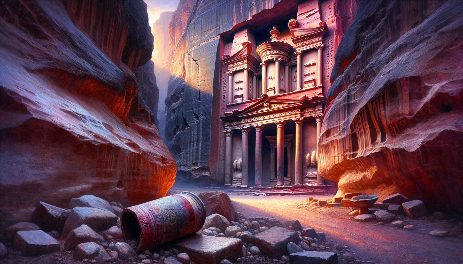
The Treasury Was a Tomb
Al-Khazneh, twenty-five meters wide and almost thirty-nine meters high, was carved at the beginning of the first century CE during the reign of Aretas IV Philopatris (ruled c. 9 BCE-40 CE). The facade combines a six-columned lower portico with an upper level of broken pediment flanking a tholos, the cylindrical drum at the center carrying a stone urn. Local Bedouin tradition held that the urn contained pharaonic treasure, which is the source of the name and of the bullet scars across its surface from generations of riflemen hoping to crack it open. The urn is solid sandstone; it was never a vessel. Excavations in 2024 confirmed a tomb chamber beneath the floor with at least twelve burials, securing the building’s identification as a royal mausoleum, possibly Aretas IV’s own. The Hellenistic figures on the upper register, Castor and Pollux flanking what is most likely a syncretized Isis-Tyche, place the Treasury at the high cosmopolitan end of Nabataean self-presentation, as the Smarthistory essay on Petra’s rock-cut facades documents [1].
The Monastery Was Probably a Cult Hall
Ad-Deir is the largest rock-cut facade in Petra at roughly forty-seven meters tall and forty-eight wide, sitting at the end of an eight-hundred-step climb above the city center. The interior is a single square chamber with a broad niche in the back wall, the kind of arrangement scholars now read as a triclinium for ritual feasting, possibly a banquet hall associated with the cult of the deified king Obodas I (ruled c. 96-86 BCE). The “Monastery” name comes from later Christian crosses scratched into the inner walls, when the chamber may have been repurposed as a chapel during the Byzantine period.
The Hydraulic City: Cisterns, Dams, and the Population Question
The most consequential thing about Petra, after the carved facades, is its water. The basin sits in a region that receives only about ten centimeters of rainfall a year, almost all of it concentrated in a few winter storms capable of generating destructive flash floods. The Nabataean engineers turned both problems into a single solution.
The Network
More than two hundred cisterns, dozens of catchment dams, and an estimated thirty miles of ceramic pipelines distributed water from springs at Ain Musa, Ain Brak, and Ain Dibdiba toward the urban center. Stepped dams across the Wadi Mataha and the Wadi Musa siphoned flash-flood water into storage rather than letting it scour the carved tombs. Inside the city, terracotta pipes ran in dressed channels with calibrated gradients, the diameters and slopes designed to keep flow turbulent enough to prevent sediment buildup. Charles R. Ortloff and the Swiss conservator Ueli Bellwald have mapped the network in detail; their work places Petra alongside Roman aqueduct engineering as one of the more sophisticated arid-land hydraulic systems of antiquity, as the American Society of Civil Engineers’ designation of Petra as an International Historic Civil Engineering Landmark reflects [2].
Capacity and the Open Question
How many people the system actually sustained at peak is a live question. Britannica gives a range of ten thousand to thirty thousand. Hydraulic models published by Ortloff in the early 2000s computed sufficient daily delivery for roughly twenty to thirty thousand inhabitants under normal-rainfall conditions. More recent work, including a 2021 paper in Levant on the social dimensions of water management, argues that strictly engineering models understate the institutional and seasonal complications that shaped real-world use. The sophistication of the network is documented; the exact peak population it could support is not yet a closed question, and current scholarship treats the thirty thousand figure as the upper bound of a plausible range rather than as an established fact.
From Roman Province to Earthquakes and Withdrawal
In 106 CE, the emperor Trajan annexed the Nabataean kingdom and incorporated it into the new Roman Provincia Arabia. Petra continued as a major regional center, briefly designated a metropolis, and in the second century CE received a colonnaded street and a refurbished theater capable of seating about eight thousand. Trade routes gradually shifted northward toward Palmyra and southward toward the Red Sea ports, and Petra’s commercial centrality thinned across the third and fourth centuries.
The 363 and 551 Earthquakes
A major earthquake on 18 or 19 May 363 CE, recorded in a contemporary letter attributed to the bishop of Jerusalem Cyril, damaged half the city and crippled the water system. The Nabataean pipework, dependent on precise gradient and well-mortared joints, was uniquely vulnerable to the disruption a strong tremor produces. The 551 CE Beirut earthquake delivered a second hard blow. Recovery was partial. The Petra Papyri, a carbonized archive of sixth-century legal documents excavated from the Byzantine church on the city’s north ridge, show that Petra remained an inhabited Christian town into the late sixth century, with land contracts dated into the 590s [3]. The withdrawal that followed was gradual, and the date conventionally given for substantive abandonment, around 700 CE, marks the end of the dense urban phase rather than the end of all habitation.
Eight Centuries Without Outsiders
Between roughly 700 CE and 1812, Petra disappeared from European awareness without disappearing from the landscape. Crusader-era fortifications were briefly garrisoned at the al-Wu’aira and al-Habis outposts in the twelfth century, but for most of the medieval and early modern centuries the basin was the home of local Bedouin, especially the B’doul tribe, who lived among the tombs and grazed their goats in the wadis. They knew where the springs ran and which tombs were dry enough for winter shelter. They did not need the Nabataean kingdom to remember Petra.
Burckhardt and the European “Rediscovery”
Johann Ludwig Burckhardt (1784-1817), a Swiss orientalist trained at Cambridge in Arabic and Islamic jurisprudence, traveled under the patronage of the African Association as Sheikh Ibrahim ibn Abdallah. On 22 August 1812, en route from Damascus to Cairo, he heard local report of magnificent ruins near the supposed tomb of Aaron on Jabal Haroun. Knowing that an open declaration of European curiosity would have ended his journey, he told his Bedouin guide that he wished to sacrifice a goat at Aaron’s tomb, and used the day’s circuit through the Wadi Musa basin to walk the Siq, register the Treasury, the theater, and the urn-tombs in his journal, and exit before suspicion gathered.
Burckhardt’s posthumous Travels in Syria and the Holy Land, edited by William Martin Leake and published in 1822, supplied European scholarship with the first detailed account of Petra since classical antiquity. The conventional phrase “rediscovery” is, in the precise sense, a misdescription. Petra was never lost to its Bedouin inhabitants; it was lost only to a European imaginary that had inherited the place from Strabo and Eusebius. Burckhardt’s achievement was the achievement of writing down, in a literate European register, what local people had been navigating for centuries, as the University of Cambridge’s bicentenary feature on Burckhardt’s journals notes in its handling of the term.
Modern Excavation: ACOR and the Finnish Project
Sustained scientific excavation began in the early twentieth century and accelerated after Jordanian independence in 1946. The American Center of Research, formerly the American Center of Oriental Research and known as ACOR, became one of the principal venues for fieldwork after its Amman base was established in 1968. Patricia Maynor Bikai (1943-2025), ACOR’s associate director through the 1990s, led the excavation of the Petra Church and the Blue Chapel on the city’s north ridge, work that recovered an extraordinary mosaic floor and the carbonized papyri that have since rewritten the city’s late-antique chronology. Her 2020 monograph with Megan A. Perry and Chrysanthos Kanellopoulos, Petra: The North Ridge, remains a standard reference [4]. A second major program, the Finnish Jabal Haroun Project, ran from 1997 to 2007 under chief archaeologist Zbigniew T. Fiema (University of Helsinki) and director Jaakko Frösén, focused on the Byzantine pilgrimage complex and the Nabataean sanctuary that preceded it on the high plateau below the summit of Aaron’s mountain.
UNESCO, Tourism, and the Question of Custodianship
Petra was inscribed on the UNESCO World Heritage List in 1985 under cultural criteria and was added in 2007 to the populist New Seven Wonders of the World list, a designation with no UNESCO standing but considerable tourism consequence. The pressure of tourism, combined with the inherent vulnerability of carved sandstone, has made conservation a continuing concern, coordinated in part by the Petra National Trust, founded in 1989.
In 1985, around the same time as the UNESCO inscription, the Jordanian government relocated the B’doul Bedouin from inside the archaeological park to a purpose-built village at Umm Sayhoun above the basin. The relocation has remained contested. Many Bedouin families continue to work in the park as guides and traders, and “the cultural space of the Bedu in Petra and Wadi Rum” was inscribed on the UNESCO Representative List of Intangible Cultural Heritage in 2008. Who speaks for Petra, and on what terms, is not closed.
What Petra Asks Us to Hold Open
Petra resists the impulse to flatten its strangeness into a single story. The city is Nabataean and Hellenistic and Roman and Byzantine and Bedouin, in a sequence that overlaps rather than supplants. The water network demonstrates engineering competence at a level scholars are still calibrating, the carved facades are archaeological documents in stone, and the 1812 European announcement is real as an archaeological event and false as a claim about the site itself. Reading Petra carefully means refusing the easier romantic frame and accepting the layered, complicated thing the rock and the records actually preserve.
Frequently Asked Questions
Who built Petra?
The Nabataeans, an Arab confederation who spoke Aramaic and controlled the incense and spice trade between southern Arabia and the Mediterranean. Their kingdom flourished from roughly the fourth century BCE until 106 CE, when Trajan annexed the territory as the Roman Provincia Arabia.
When was Petra founded as the Nabataean capital?
Archaeological evidence places Nabataean settlement at the site by at least the fourth century BCE, with the city’s most ambitious rock-cut monuments belonging to the first century BCE and first century CE, especially the reign of Aretas IV Philopatris (c. 9 BCE-40 CE).
Who rediscovered Petra in 1812?
Johann Ludwig Burckhardt (1784-1817), a Swiss orientalist working under the alias Sheikh Ibrahim ibn Abdallah, visited Petra on 22 August 1812. He was the first European in modern times to record the site. Local Bedouin had lived among the tombs continuously, so the term “rediscovery” is a Western framing.
Was the Treasury at Petra actually used as a treasury?
No. Al-Khazneh was a royal mausoleum, almost certainly built for Aretas IV in the early first century CE. The “Treasury” name comes from a later Bedouin tradition that the urn at the top of the facade contained pharaonic gold. The urn is solid sandstone. Excavations in 2024 confirmed burials beneath the floor.
How did Petra get its water?
Through a combined system of springs, more than two hundred cisterns, catchment dams across the wadis, and roughly thirty miles of ceramic pipelines and stone-cut channels with calibrated gradients. The springs at Ain Musa, Ain Brak, and Ain Dibdiba supplied the year-round baseflow.
How many people lived in ancient Petra?
Estimates range from around ten thousand to thirty thousand at the city’s first-century-CE peak. The thirty thousand figure is widely cited but should be treated as the upper end of a plausible range. The exact carrying capacity of the Nabataean water network at peak demand remains an active research question.
What earthquakes damaged Petra?
Two are particularly important. The 18 or 19 May 363 CE earthquake destroyed roughly half the city and crippled the water system. A second major event in 551 CE, sometimes linked to the Beirut quake of that year, caused further damage. Habitation continued, in reduced form, into the early Islamic period.
When was Petra abandoned?
Substantive urban abandonment is conventionally dated to around 700 CE, though Bedouin habitation of the basin continued without interruption afterward. The 363 and 551 earthquakes, combined with the gradual shift of trade routes, drove the long decline.
Why is Petra called “the Rose City”?
The Cambrian-age Umm Ishrin sandstone of the basin weathers in shades from pale rose to deep oxblood. The phrase “rose-red city, half as old as time” is from the 1845 sonnet “Petra” by John William Burgon, written before he had ever visited the site.
Is Petra a UNESCO World Heritage Site?
Yes. Petra was inscribed on the UNESCO World Heritage List in 1985 under cultural criteria. It was added to the populist New Seven Wonders of the World list in 2007, a separate designation with no UNESCO involvement. The Petra Papyri were inscribed on the UNESCO Memory of the World Register in 2017.


