By Emilia Wellesley · Published May 6, 2026 · Updated May 13, 2026
What Is the Yonaguni Monument?
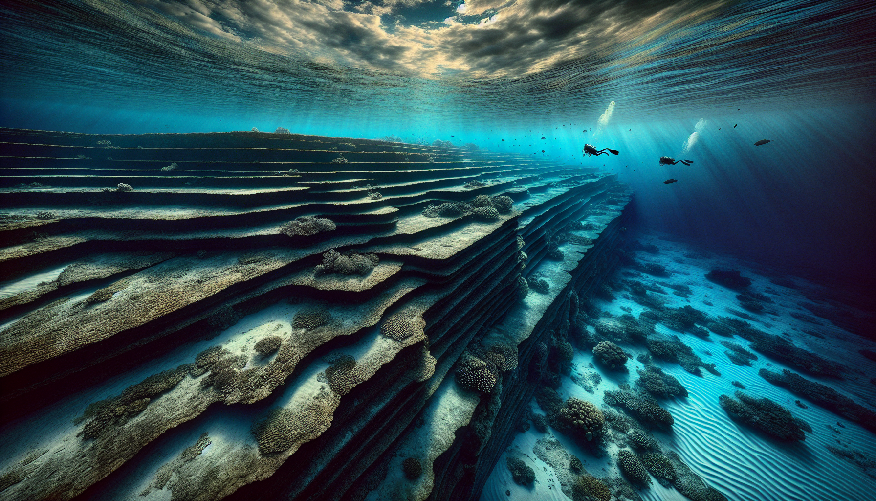
The Yonaguni Monument is a submerged rock formation off the southern shore of Yonaguni-jima, the westernmost inhabited island of the Ryukyu archipelago in Okinawa Prefecture, Japan. It rests at depths of roughly five to twenty-five metres in cobalt water, and its largest face descends in stair-like terraces that, to a diver swimming above them, can read like the cut courses of a coastal pyramid. The geology underneath those terraces is medium to very fine sandstone of the Lower Miocene Yaeyama Group, deposited about twenty million years ago, and that rock is famously well-jointed.
The site was first reported in 1986 by Kihachiro Aratake, then a director of the Yonaguni-Cho Tourism Association, who descended on the southern reef looking for hammerhead sharks and surfaced with a story about cut steps on the seabed. The marine geologist Masaaki Kimura (born 1940) of the University of the Ryukyus soon began the dives that would, over the next two decades, make him the most-cited proponent of an artificial reading [1]. Mainstream geomorphology, represented in the published record by Robert M. Schoch (born 1949) of Boston University and the Pacific-island specialist Patrick D. Nunn (born 1955) of the University of the Sunshine Coast, has steadily held that the monument is a natural feature carved by wave action along the Yaeyama sandstone’s bedding planes and joint sets [2][3].
This guide walks through the discovery, the two interpretive frames, the geomorphology that explains most of what divers see, and the narrow questions that remain genuinely open. The aim is to lead with the geological consensus while honouring the features that have kept the popular argument alive, situating the formation within the broader landscape of historical and archaeological mysteries.
Discovery on the Southern Reef
Yonaguni-jima sits about a hundred kilometres east of Taiwan, and its southern coast drops quickly into the East China Sea along a series of stepped sandstone benches. Divers who know the reef visit it as much for the resident hammerhead population as for the formations. Aratake, a working dive operator rather than a geologist, came across the largest terrace block on a routine survey [1]. Photographs of stair-like risers and right-angle corners began circulating in Japanese diving media within the year, and the site rapidly drew interest from researchers at the University of the Ryukyus.
Kimura’s First Surveys
Kimura, a marine geologist with a doctorate from the University of Tokyo (1968) and based at the University of the Ryukyus from 1977 to 2002, made his first descents on the monument in the late 1980s and continued returning into the 2000s [4]. His early surveys focused on the largest structure: a ten-tier terrace face that rises roughly twenty-five metres from the reef floor to within five metres of the surface, with its main face oriented south-southeast. By the early 1990s he had drafted the working hypothesis he would defend across his later publications, that some portion of what he was photographing had been deliberately cut, dressed, or at least heavily modified by a coastal population active before the last marine transgression [4].
The Layout Underwater
The named features that surface in the popular literature, and that Kimura argues for as cultural objects, cluster along a roughly three-hundred-metre stretch of the reef. Among them are a “main terrace” of broad horizontal benches, a so-called “Turtle” relief where erosion has produced a vaguely reptilian outline, a tall standing slab popularly read as an archway, narrower “passages” between blocks, and what Kimura has at various points described as a stage, a triumphal arch, and a stadium [5]. The dimensions are real and verifiable; the interpretive labels are not.
The Manufactured-Monument Reading
Kimura’s case for human involvement is the strongest version of the artificial reading on offer. He has argued, in National Geographic’s 2007 feature, that the largest structure “looks like a complicated, monolithic, stepped pyramid that rises from a depth of 25 meters” and that ten structures off Yonaguni plus five near the main Okinawan island make up a coherent built complex of roughly three hundred by one hundred and fifty metres [5]. He has at different times associated the site with the first-century polity of Yamatai and, in earlier statements, with the mythical lost continent of Mu, although the Mu framing has receded in his more recent positions [4].
Why the Idea Took Hold
Several features of the site lend themselves to an artificial reading at first sight. The risers are right-angled, the treads are flat, and the largest face is oriented along a single compass bearing. Photographs taken with a wide lens compress the scene and emphasise the geometry. The monument also lies at depths consistent with sea levels of the last glacial maximum, when the Pacific stood roughly a hundred and twenty metres below its present mean. A culture working a coastal terrace ten thousand years ago would have left exactly this kind of stepped face, if there had been one to leave.
What the Hypothesis Requires
For Kimura’s reading to hold against the geological alternative, several conditions need to be satisfied. The blocks have to be detached from the bedrock, not still continuous with it. The cuts have to be tool marks, not joint surfaces. There must be a working assemblage somewhere in the catchment, a hammerstone, a chisel, a bead, a midden, anything that places a coastal population on this reef during the relevant window. None of these conditions has so far been met.
The Geological Reading: Sandstone, Bedding, Joints
The reading that the working geomorphologists settled on is less photogenic and more precise. The Yaeyama Group sandstone is what petrographers call a thinly bedded clastic sequence with two strong joint sets running close to ninety degrees apart. Where this rock is exposed to long-term wave action, it weathers along its bedding planes and along its joint planes simultaneously, producing rectangular blocks, stair-like risers, and corner intersections that are nearly orthogonal. Schoch, who first dived the monument in 1997, described what he saw in plain terms in Voices of the Rocks (Crown, 1999) and again in Pyramid Quest (TarcherPerigee, 2005): the sandstone shows numerous well-defined parallel bedding planes and criss-crossed sets of vertical joints, and these are the fingerprints of the geometry that divers find so striking [2][6].
Schoch’s Field Reading
In a 2007 interview with National Geographic, Schoch put the case in a sentence: “It’s basic geology and classic stratigraphy for sandstones, which tend to break along planes and give you these very straight edges” [5]. The same sentence does much of the explanatory work that the artificial reading needs an entire civilisation to do. Wave action carves a softer bed; a stronger bed remains as a tread. Joints in the harder bed open under tidal loading; the resulting block falls away; the next bed is exposed. Continue the process across the post-glacial transgression, and the geometry of the Yonaguni Monument is what you get.
Wichmann and Nunn on the Same Rock
Two further geological assessments support the natural-formation reading. The German marine geologist Wolf Wichmann dived the site in 1999 and 2001 for Der Spiegel and concluded that the formations are entirely the product of natural weathering on a strongly jointed sandstone [7]. Patrick D. Nunn, professor of geography at the University of the Sunshine Coast and a leading authority on Pacific Holocene sea-level history, has likewise argued that the apparent architecture is best read as weathering and erosion acting on the bedding and linear joints of the host lithology [3]. Neither the Japanese Agency for Cultural Affairs nor the government of Okinawa Prefecture has classified the site as a cultural artefact [8].
Sea Level, Sandstone, and Stair Treads
The geomorphological account becomes sharper when the sea-level history of the western Pacific is laid alongside it. During the last glacial maximum, around twenty thousand years ago, ocean levels in this region stood roughly a hundred and twenty metres below their present mean. As the ice sheets melted, the Pacific rose in pulses, and Yonaguni’s southern reef cycled through stand-still levels for centuries at a time. A wave-cut platform forms at each stand; when sea level rises again, that platform is preserved underwater while the next stand cuts another farther up. The eventual record is a staircase of terraces. That is, in plain terms, what the largest of the Yonaguni structures resembles.
The Right-Angle Joint Pattern
The piece of the puzzle that does the most work is the joint geometry of the host sandstone. In the Yaeyama Group, bedding runs roughly horizontal and the dominant joint sets run vertical at near-orthogonal angles. Where this rock is wave-cut, the resulting blocks have flat tops, vertical sides, and right-angle corners as a matter of basic structural geology. The same pattern is visible in dry exposure on Yonaguni’s northeast coast, where no diver has ever proposed that an ancient stonemason was at work [2]. The geometry is in the rock, not the architect.
Pareidolia and the Turtle
Some of Kimura’s most-discussed individual features, the “Turtle” relief in particular, are best understood as pareidolia: the brain’s tendency to read faces, animals, and structures into ambiguous textured surfaces. A weathered hollow above two protrusions resembles a turtle if the diver is looking for one, and it resembles two adjacent erosional pockets if the diver is not. Schoch’s verdict on these specific reliefs has been consistent since his first descent: they are natural scratches and erosion patterns, not relief carving [2][6]. The narrowest defensible version of the artificial reading at Yonaguni, the one mainstream geology continues to hold open, is not that the monument was built but that some of its surfaces may have been used or modified by coastal populations after they emerged near sea level.
What Would Distinguish the Two Readings
The two interpretive frames make different predictions, and those predictions can in principle be tested. A genuinely cut and dressed block should preserve tool marks at a different scale from the host rock’s natural joints. A bedrock terrace should show continuous bedding from “block” to underlying mass. A built complex should leave an associated artefact assemblage within reach of the site. Three lines of investigation would, together, close the case as nearly as such things ever close.
Continuity with the Bedrock
The first test is structural. Are the blocks detached from the underlying mass, or are they continuous with it? Photogrammetric and side-scan sonar surveys conducted around the monument have repeatedly shown that the major faces remain part of the same coherent rock body. Continuous bedding planes can be traced from one supposed “block” into the next, which is not what one finds at a quarried site [2].
Tool Marks Versus Joints
The second test is microstructural. Tool marks on dressed stone leave parallel grooves at a tool’s working scale, often a few millimetres wide, set at angles independent of the rock’s grain. Joint surfaces, by contrast, follow the rock’s existing fabric and show conchoidal or planar fracture textures consistent with mechanical weathering. The Yonaguni surfaces, where they have been examined closely, show the second pattern, not the first.
The Missing Assemblage
The third test is archaeological. Built complexes leave debris. A coastal population working stone for centuries leaves cores, flakes, hammerstones, broken tools, and food refuse somewhere in the catchment. None of this assemblage has been recovered from Yonaguni’s terrestrial surveys or from the seabed adjacent to the monument [8]. The absence is not, by itself, decisive. It is, however, what one expects of a natural feature.
The Atlantis-of-the-Pacific Frame, and Why It Fails
The most popular framing of the site, that Yonaguni is the Pacific equivalent of Atlantis or a relic of the lost continent of Mu, has had a long media life and almost no geological purchase. The Atlantis frame requires a coherent civilisation, a destruction event, and a cultural inheritance, and the Yonaguni record supplies none of these. The Mu hypothesis, which Kimura himself has largely set aside in his more recent statements, treats a Theosophical-era literary invention as if it were a geographical referent. The geomorphology does not need either frame.
The Narrow Open Question
There is a narrower, defensible version of the artificial reading worth keeping on the table. It is the version Schoch has consistently allowed: the monument may be a fundamentally natural structure that was utilised, enhanced, or modified by humans during a window when its highest terraces stood near sea level [2][6]. Holding that question open is not the same as endorsing a Pleistocene pyramid or an underwater capital. It is the discipline of treating a coastal site as a place where geology and culture can, in principle, share a working surface.
Reading the Monument Carefully
The Yonaguni Monument is, on the best available evidence, a coherent natural feature carved out of Lower Miocene sandstone by tens of millennia of wave action against a strongly jointed host rock, finished by the post-glacial rise of the Pacific into its present position. Naming both interpretive frames openly, manufactured monument from a lost coastal civilisation versus wave-cut platform on a jointed sandstone reef, is the right place to start. Showing what evidence would prefer one frame over the other is the right place to land. The published evidence prefers the joint pattern to the architect. The story has not lost its strangeness; it has only changed registers, from a sunken city to a slow record of how a Pacific coastline emerges and submerges, and how patient water can become.


