By Theodora “Theo” Marsh · Published May 8, 2026 · Updated May 13, 2026
Last reviewed: May 8, 2026.
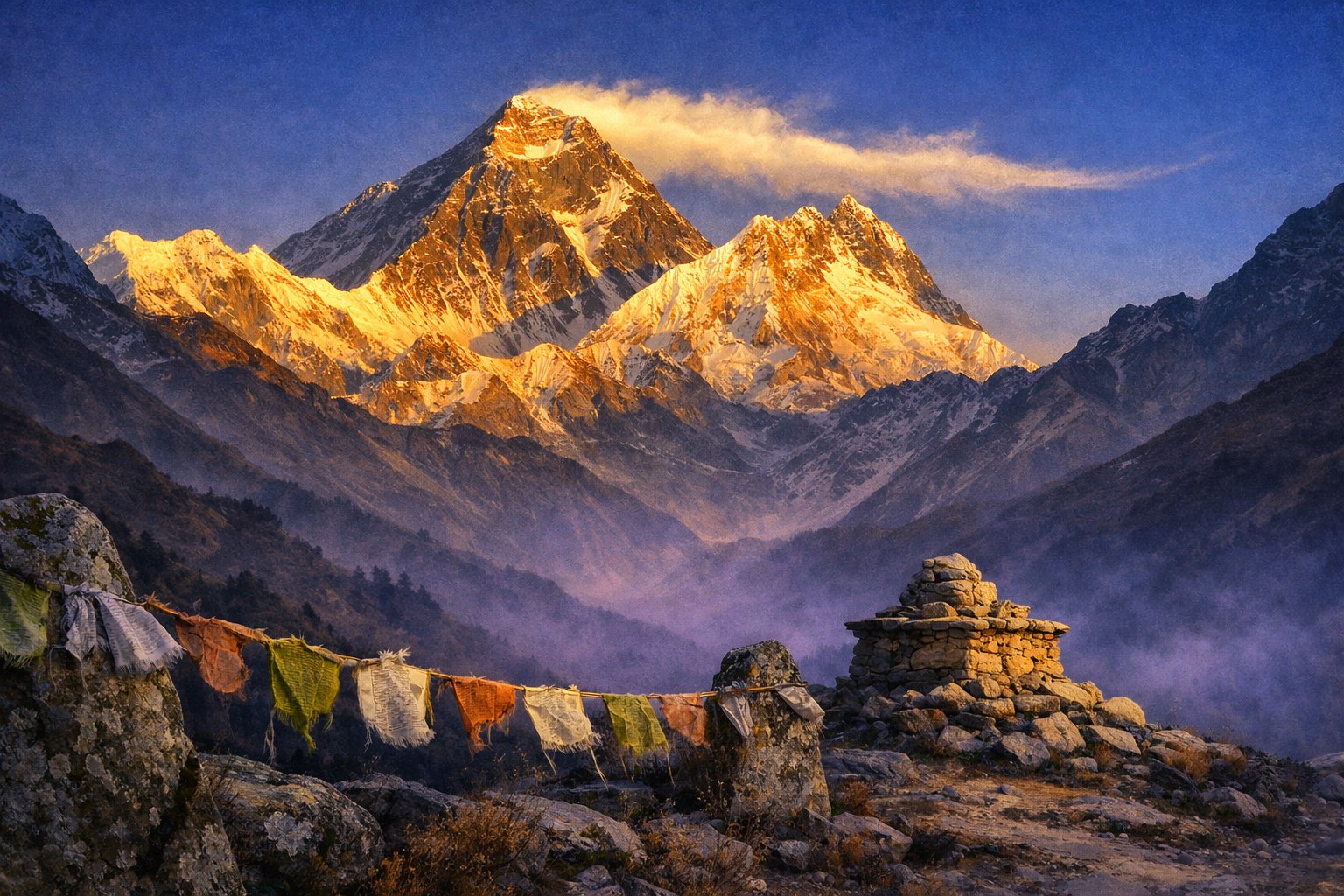
Mount Everest rises along the border of Nepal and the Tibet Autonomous Region of China, 8,848.86 metres above sea level by the joint resurvey of 2020, and the wind across its summit ridge is, on most days, a steady high-altitude jet stream blowing eastward at speeds that would topple a tower. Surveyors call it the world’s highest peak. Sherpas call it Chomolungma, Mother Goddess of the World, and Tibetans the same in slightly different transliteration. Nepalis call it Sagarmatha, head-in-the-sky. The mountain answers to all three names, and the friction between them — between a measured object and a working deity — is the reason the place has held the human imagination since before the British surveyors of the nineteenth century set their theodolites against it.
The Direct Answer: What Makes Everest Mystically Distinct
Mount Everest is mystically distinct because three living religious cultures — Sherpa Buddhist, Tibetan, and Nepali Hindu — read its 8,848.86-metre summit not as a peak to be conquered but as the residence of named deities, chiefly Miyolangsangma, the long-life goddess of inexhaustible giving in Tibetan Buddhism [1][2]. Climbers who reach the death zone above 8,000 metres still receive a Sherpa-led puja ceremony before entering it [3].
Standing in the Khumbu, Looking North
The first place a foreign visitor sees Everest with the eye and not the photograph is usually a tea-house ridge above Namche Bazaar, at about 3,800 metres, on the third or fourth day out of Lukla in the Khumbu valley of eastern Nepal. The mountain rises behind a curtain of nearer peaks — Ama Dablam pulls the eye, Lhotse stands closer — and Everest itself is the dark trapezoid in the middle distance, its summit pyramid usually trailing a banner of cloud in the upper troposphere. The trail to base camp continues for another six or seven days through Tengboche, Pheriche, and Lobuche; a registered Sherpa or Tamang guide working under a Nepal Mountaineering Association permit will pace the climb to allow acclimatisation, and will, almost without fail, point out the prayer-flag lines and the carved mani-stones along the trail before pointing out the mountain itself [4].
The geology under the place is not what an inexperienced eye expects. The summit pyramid of Everest is layered with the Qomolangma Formation, a band of Ordovician marine limestone roughly 470 million years old, deposited on a shallow tropical sea floor and then thrust upward, with the rest of the Himalayan crest, by the slow continental collision of the Indian and Eurasian plates that began between fifty and sixty million years ago and continues at perhaps a millimetre a year of measurable uplift today [5]. The trilobite fossils preserved in that summit limestone — sea-floor animals lifted to the highest point on Earth — are themselves a quiet argument about the mountain. The peak is, in stratigraphic terms, an upended seabed.
The Mountain in Three Cosmologies
No single name holds the mountain. Tibetan and Sherpa traditions know it as Chomolungma, often translated Mother Goddess of the World or Goddess Mother of Mountains; the literal compounding is “chomo” (holy mother) plus “lungma” (commonly read as district or valley, with esoteric readings in the Buddhist tantric literature), and the Sherpa community has used the name for centuries before any British surveyor’s catalogue [1][6]. The Nepali name Sagarmatha, given currency in the twentieth century by the historian Baburam Acharya, joins “sagar” (sky) and “matha” (head) — the head-in-the-sky, or as some translate it, brow of the heavens [6][7]. The English name Everest was attached to the peak in 1865 by the Royal Geographical Society over the mild objection of George Everest himself, who preferred indigenous nomenclature; Andrew Waugh, his successor as Surveyor-General of India, argued that no single local name could be reliably established at the time, an argument since superseded by ample local-language evidence [7].
The deity at the heart of the Sherpa-Buddhist reading is Miyolangsangma, in some Tibetan-Buddhist traditions one of the Five Sisters of Long Life (Tseringma chenga), a class of mountain-dwelling protector goddesses whose chief is identified with the peak of Gauri Shankar; in others Miyolangsangma is treated singly as the ridge-resident of Chomolungma. Iconographically she rides a tigress, holds a bowl of jewels and a mongoose that disgorges treasure, and her virtue is inexhaustible giving — a notable contrast to the Western mountaineering imagination of the peak as adversary [1][2]. The Sherpa lhap-so ceremony at Everest Base Camp, conducted by a lama from one of the local monasteries (Tengboche being the largest), is in formal Buddhist terms a request to Miyolangsangma for permission to enter her territory; juniper is burnt for purification, a chorten is built from prayer-flag stones, and the climbing equipment is laid out for blessing before any climber moves through the Khumbu Icefall above base camp [3].
The Hindu Layer and the Pre-Buddhist Substrate
The Nepali Hindu reading layers onto the Buddhist one without contradicting it. Sagarmatha National Park, gazetted in 1976 and inscribed as a UNESCO World Heritage Site in 1979, is administered through the Nepali state, and the mountain’s southern flank carries Hindu pilgrim resonances even where it does not carry temples. The Solu-Khumbu region’s Sherpa population is itself a fifteenth-to-sixteenth-century migration out of the Kham region of eastern Tibet — the name Sherpa means “people from the east” — and the religious vocabulary of the high valleys is Nyingma Buddhist with older Bon substrate, layered with locally adapted yul-lha (territorial deity) cults that pre-date both [8].
The Death Zone, the Mountaineering Canon, and the Mystery
The phrase “death zone” entered mountaineering literature through Edouard Wyss-Dunant in 1953 and now describes any altitude above 8,000 metres, where atmospheric pressure falls below roughly 356 millibars and the partial pressure of oxygen is no longer sufficient to sustain human life for an extended interval [9]. On Everest the death zone begins on the South Col at 7,920 metres and continues to the summit; climbers acclimatised over weeks of rotations may function inside it for a window measured in hours, not days, and the ratio of summit attempts to deaths above the South Col is a matter of long literature.
The first confirmed summit was made on 29 May 1953 at 11:30 in the morning by Edmund Hillary of New Zealand and Tenzing Norgay, the Nepali-Indian Sherpa mountaineer who was attempting Everest for the sixth time. They climbed by what is now called the South Col route, in the ninth British expedition to the peak, under the military-style logistics of Colonel John Hunt, and the news reached London on the eve of Queen Elizabeth’s coronation [10]. The summit photograph that survives — Tenzing on the top with his ice-axe lifted, an Indian, Nepali, British and United Nations flag in his hand — was taken by Hillary; the corresponding photograph of Hillary on the summit was never made because Tenzing, by his own later account, did not know how to operate the camera and Hillary did not want to spend training time on it during the assault [10].
The earlier mystery of George Mallory and Andrew Irvine has held the popular imagination for a century. On 8 June 1924, on the third British expedition, Mallory and Irvine were last seen by their teammate Noel Odell ascending what is now called the Second Step on the Northeast Ridge, “going strong for the top,” before cloud closed in. They did not return. Mallory’s body was discovered on 1 May 1999 by the climber Conrad Anker, working with the Mallory and Irvine Research Expedition organised by Eric Simonson and the historian Jochen Hemmleb; it lay at 8,156 metres on a shelf below the summit pyramid, well preserved by the cold, with rope-and-fall injuries consistent with a descent and the absence of the small Vest Pocket Kodak camera that he had carried. Andrew Irvine’s partial remains were located in 2024 by a National Geographic team during a descent of the Rongbuk Glacier on the North Face. Whether the pair reached the summit twenty-nine years before Hillary and Tenzing remains, with no recovered film, an open historical question [11].
The Yeti and the Limits of the Archive
The Yeti enters the English-language record through the early-twentieth-century British expeditions: Howard-Bury’s 1921 Reconnaissance, the 1925 photograph of disputed footprints at the Zemu Gap, Eric Shipton’s 1951 photograph of a single track on the Menlung Glacier near the Nepal-Tibet border. The folkloric register inside the high valleys is older and richer; the Sherpa lexicon distinguishes several beings (mi-go, dzu-teh, yeh-teh) where Western reception flattens them into one. Reinhold Messner — the first solo, no-supplementary-oxygen ascent of Everest from the Tibetan side on 20 August 1980, by a new variation on the North Face — devoted the eleven years after a 1986 night encounter in eastern Tibet to a long ethnographic search published as My Quest for the Yeti in 1998. His conclusion, that the folkloric Yeti is rooted in the Tibetan blue bear and the brown bear (the local chemo or dremo), satisfied no one fully and remains the working ethnological reading among Himalayan field zoologists [12].
The Third Pole: A Climatic and Hydrological Reading
The phrase “Third Pole” — applied to the Hindu Kush, Karakoram, Himalaya, and Tibetan Plateau as a single cryospheric system — entered scientific currency in the late twentieth century to describe the largest reservoir of frozen freshwater outside the Arctic and Antarctic. The Everest region holds an instrument record going back to the 1950s and an ice-core record going back tens of thousands of years; warming in the Mount Everest region has been measured at roughly 0.33 degrees Celsius per decade since 1960, and a 2022 study from the University of Maine reported that the South Col Glacier, at 7,945 metres the highest measured glacier on Earth, has lost the equivalent of two thousand years of ice accumulation in the last three decades [13][14]. The hydrological consequence reaches well beyond the mountain. The Indus, Ganges (here the Karnali tributary), and Brahmaputra all draw on Himalayan ice; the meltwater feeds nearly two billion people downstream.
A field-historian’s reading of the Third Pole framing notes that it is, like the Sherpa naming of the mountain as Mother Goddess of inexhaustible giving, a recognition of the peak as a hydrological source. The two readings are not in conflict. Climate science and Tibetan Buddhist iconography arrive at the same observation by different routes: the mountain as a giver of water, and the giving as in trouble.
The Visitor’s Ethics
The Khumbu trekking permit and the Sagarmatha National Park entry fee are administered by the Nepali state through registered agencies in Kathmandu, with a separate climbing permit required for any attempt above base camp. The Tibet-side approach via Rongbuk Monastery requires a Tibet Travel Permit and an Aliens’ Travel Permit, and a registered Tibetan guide. On both sides the convention among careful visitors is the same: do not climb the lower flanks for a clearer photograph, do not photograph faces in prayer without consent, do not bring drone equipment within the ritual perimeter of a monastery, and do not name the dead on the upper mountain in casual conversation — the Sherpa community has lost a great many of its sons and daughters there, and the rainbow valley below the South Col holds frozen bodies that have not been recoverable. The mountain has held its names and its dead for as long as we have records of either; a careful visitor adds neither name nor noise.
Frequently Asked Questions
How tall is Mount Everest by the most current official measurement?
Mount Everest stands at 8,848.86 metres (29,031.7 feet) above sea level, the height jointly announced by Nepal and China on 8 December 2020 after coordinated GPS, snow-radar, and gravimetric surveys from both sides of the peak. This figure resolved a long-running disagreement between the prior Indian-survey snow height of 8,848 metres and the prior Chinese rock height of 8,844 metres [5][13].
What does Chomolungma mean and where does the name come from?
Chomolungma is the Tibetan and Sherpa name for the mountain, conventionally translated Mother Goddess of the World or Goddess Mother of Mountains. The compound joins “chomo” (holy mother, female deity) with “lungma,” whose register ranges across district, valley, and a body of esoteric Buddhist tantric readings. The name predates any Western nomenclature for the peak [1][6].
Who is Miyolangsangma and how is she connected to Everest?
Miyolangsangma is a Tibetan Buddhist long-life goddess associated in many local traditions with the summit of Chomolungma, where she is held to reside. She is depicted riding a tigress, holding a bowl of jewels and a treasure-disgorging mongoose; her virtue is inexhaustible giving. The Sherpa puja ceremony at Everest Base Camp is, in formal terms, a request to her for permission to enter the upper mountain [1][2].
What is the Sherpa puja ceremony at base camp?
The lhap-so or puja ceremony is a Tibetan Buddhist blessing rite performed by a lama at Everest Base Camp before any expedition crosses into the upper mountain. Juniper is burnt for purification; a stone chorten is built and prayer flags strung; bells, drums, and ritual horns accompany hours of chanting; climbing equipment is blessed; participants finally exchange tsampa flour and small offerings. Many Sherpa climbers will not enter the Khumbu Icefall without it [3].
Why is Everest called the Third Pole?
The “Third Pole” describes the high mountain region of the Hindu Kush, Karakoram, Himalaya, and Tibetan Plateau as the world’s largest reservoir of frozen freshwater outside the polar regions. The Everest region is its emblematic peak. The framing carries both a glaciological reading (ice mass, climate sentinel) and an ethical one: meltwater here feeds the Indus, Ganges, and Brahmaputra basins downstream [13][14].
Did George Mallory and Andrew Irvine reach the summit in 1924?
It remains an open historical question. Mallory and Irvine were last seen alive on 8 June 1924, “going strong for the top” on the Northeast Ridge by their teammate Noel Odell. Mallory’s body was found on 1 May 1999 by Conrad Anker; Andrew Irvine’s partial remains were located in 2024 by a National Geographic team. Without recovered film from the Vest Pocket Kodak camera Mallory carried, no proof of summit exists [11].
What is the death zone and where does it begin on Everest?
The death zone is the region above approximately 8,000 metres of altitude, where atmospheric pressure (about 356 millibars) is no longer sufficient to sustain human life for an extended interval; the term was coined by the Swiss physician Edouard Wyss-Dunant in 1953. On Everest the death zone begins on the South Col at 7,920 metres and includes the entire summit pyramid [9].
Who first climbed Everest and what route did they take?
The first confirmed summit was made on 29 May 1953 at 11:30 in the morning by Edmund Hillary of New Zealand and Sherpa mountaineer Tenzing Norgay, by what is now the South Col route from the Nepali side, in the ninth British expedition under Colonel John Hunt. Tenzing was attempting the peak for the sixth time; Hillary photographed Tenzing on the summit, but no corresponding photograph of Hillary was made [10].
Did Reinhold Messner climb Everest alone?
Yes. Reinhold Messner made the first solo summit of Mount Everest, without supplementary oxygen, fixed ropes, or established camps, on 20 August 1980, by a new variation on the North Face from the Tibetan side, during the monsoon season. The climb is regarded by many in the mountaineering canon, including Jon Krakauer, as the single greatest individual ascent in the history of high-altitude mountaineering [12].
What does the Yeti tradition have to do with Everest?
Yeti folklore predates the Western mountaineering history of the peak by centuries and is rooted in the Sherpa, Tibetan, and Bhutanese cultural geography of the high Himalayas. Reinhold Messner’s eleven-year ethnographic search, published as My Quest for the Yeti (1998), traces the folkloric being to the Tibetan blue bear and the brown bear (locally chemo or dremo); the Sherpa lexicon itself preserves several distinct beings the Western register flattens into one [12].
Sources
[1] Wikipedia, “Miyolangsangma,” and Tsem Rinpoche, “Miyolangsangma, the Goddess of Inexhaustible Giving,” Buddhist iconographic compendium.
[2] Rigpa Wiki, “Miyo Lang Zangma,” Tibetan-Buddhist reference for the Five Sisters of Long Life.
[3] Field accounts, Everest Base Camp puja ceremonies, cross-referenced with Alpenglow Expeditions and Madison Mountaineering published expedition reports; iconographic notes per Alamy ethnographic photography archive.
[4] Nepal Mountaineering Association, registered guide and porter regulations, current edition.
[5] U.S. Geological Survey, “The Himalayas,” in This Dynamic Earth; Geological Society of London, “Continental/Continental: The Himalayas”; Wikipedia, “Geology of the Himalayas,” with stratigraphic dating of the Qomolangma Formation.
[6] Alan Arnette, “What’s in a Name: Everest, Chomolungma, Sagarmatha?” (December 2020 explainer); Britannica entry “Mount Everest” on naming history.
[7] Royal Geographical Society history of the 1865 naming; Montana State University, “The Naming of Mount Everest.”
[8] UNESCO World Heritage Centre file 120, “Sagarmatha National Park” (1979 inscription); Sherry B. Ortner, High Religion: A Cultural and Political History of Sherpa Buddhism (Princeton, 1989).
[9] Wikipedia, “Death Zone,” with the Wyss-Dunant 1953 etymology and the partial-pressure threshold.
[10] Wikipedia, “1953 British Mount Everest expedition” and “Tenzing Norgay”; National Geographic, “Sir Edmund Hillary and Tenzing Norgay — 1953 Everest.”
[11] Wikipedia, “Mallory and Irvine Research Expedition”; Smithsonian Magazine, “Famous Explorer’s Remains Discovered on Mount Everest” (2024); National Geographic, “Will the discovery of Sandy Irvine lead to solving Everest’s greatest mystery?”
[12] Reinhold Messner, The Crystal Horizon: Everest — The First Solo Ascent (1980); Reinhold Messner, My Quest for the Yeti: Confronting the Himalayas’ Deepest Mystery (Macmillan, 1998).
[13] NPR, “Mount Everest Gets Growth Spurt as China, Nepal Revise Elevation” (8 December 2020); Kathmandu Post, “It’s Official: Mount Everest is 8,848.86 metres tall.”
[14] Mariusz Potocki et al., “Mt. Everest’s highest glacier is a sentinel for accelerating ice loss,” npj Climate and Atmospheric Science (2022); Nature, “Observed changes in the climate and snow dynamics of the Third Pole” (2024).
For more on the broader landscape of mystical places and lost worlds in this series, see the niche overview.
For broader exploration of mystical places and lost worlds, see Understanding Earth’s Energy Grid: Ley Lines and Vortexes and Troy: The Search for Homer’s Fabled City.


