By Emilia Wellesley · Published May 4, 2026 · Updated May 13, 2026
Last reviewed: May 4, 2026.
Embark on a journey through significant facts and events of the Lewis and Clark Expedition, understanding its impact on American history, geographical knowledge, and interactions with Native American tribes.
Mission Inception and Objectives
A Presidential Mission
In an era marked by a burgeoning national identity and pressing expansionist ideals, the Lewis and Clark Expedition, implemented under the stewardship of President Thomas Jefferson, emerged as a monumental undertaking following the colossal land acquisition known as the Louisiana Purchase. In 1803, through a gratifying blend of diplomatic finesse and approximately fifteen million dollars, the United States had successfully doubled its size. Amidst widespread fervor, Jefferson, an ardent advocate for exploration and enlightenment, conceived an ambitious mission to navigate and assert American presence in these nascent territories.
Goals of Exploration
The primary directive of the expedition was an expansive assessment of the acquired Western territory, which encompassed mapping the vast landscapes and establishing an American infrastructure over newly claimed dominions. The mystical allure of finding a water route to facilitate trade and connectivity to the Pacific Ocean fashioned its secondary, albeit immensely enticing, goal. Jefferson envisioned this expedition not only as a territorial exploration but as a profound engagement with the natural world.
The multifaceted mission aimed to achieve comprehensive geographical cognizance, arrange trade connections with Native tribes, and document botanical, zoological, and ethnographic characteristics of the region. These objectives highhandedly enhanced the expedition’s importance, fostering a journey not merely of land survey but one potentially illuminating the cultural tapestries and natural splendors of the American frontier.
In encapsulating the essence of these mission objectives, Jefferson's directives laid the groundwork for a transformative voyage. This voyage catered not only to territorial expansion but significantly engaged with scientific exploration, establishing a benchmark in the annals of American exploratory narrative enduring well into subsequent centuries.
Key Members of the Expedition
The success of the monumental Lewis and Clark Expedition, often hailed as one of the great American adventures, rested heavily on the shoulders of its diverse team members. At the helm were Meriwether Lewis and William Clark, appointed as co-leaders through a direct commission from President Thomas Jefferson. Their leadership was not just about charting unknown territories but also involved managing a large, varied crew under often harsh conditions.
The Leadership
- Meriwether Lewis: Chosen for his military prowess and knowledge of natural sciences, Lewis served not only as a leader but also acted as the physician, botanist, and chief documentarian of the expedition.
- William Clark: Known for his skills as a frontiersman and his meticulous map-making expertise, Clark's contributions significantly enhanced the accuracy of the expedition's geographic recordings.
Essential Guides and Contributors
No narrative of the Lewis and Clark Expedition would be complete without mentioning Sacagawea, the Shoshone woman whose guidance and language skills were indispensable.
- Sacagawea: She navigated cultural landscapes and facilitated interactions with various Native American tribes. Her presence symbolically reinforced the peaceful intentions of the expedition to the Native tribes they encountered.
Another figure of considerable importance was York, Clark’s enslaved African-American servant, whose roles in the expedition were multi-faceted.
- York: Took on responsibilities as a scout and hunter. His interactions with Native American tribes often drew curiosity and facilitated smoother diplomatic relationships due to his striking appearance and demeanor, unfamiliar to the tribes.
Additional Members of Note
The Corps of Discovery also included figures like Toussaint Charbonneau, Sacagawea's husband, who joined as a translator.
- Toussaint Charbonneau: Though not as pivotal as his wife, his participation added layers of interaction with Native tribes.
- Other Contributing Members:
- Patrick Gass, John Ordway, and Charles Floyd (the only member to die during the journey) played crucial roles ranging from journal keeping to navigation and hunting, reflecting a team that was versatile and adaptive.
The expedition was not just a journey across the continent but a dynamic interaction of personalities and skills, each contributing to the collective success and the vast body of knowledge gathered throughout this historic journey. This intricate mesh of expertise, courage, and endurance among the team members not only facilitated the geographical and scientific achievements of the expedition but also deepened the understanding of the American frontier’s cultural and ecological diversity.
Navigating Through Waterways and Setting Camp
As Lewis and Clark embarked from St. Louis in May 1804, their keelboat pierced the silt-laden waters of the Missouri River, initiating a daunting journey into uncharted territories. The Missouri, serving both as a highway and barrier, presented a maze of tributaries, unexpected shallows, and deceptive currents. The expedition utilized additional smaller vessels known as pirogues to manage these challenges effectively, allowing for more agile navigation and exploration of narrower or shallower offshoots.
The keelboat, laden with supplies and scientific instruments, was central to the expedition's ability to push forward. As they progressed, river navigation was complemented by meticulous cartographic efforts led by Clark, who took charge of mapping the route—a task crucial for the safe passage and vital for the expedition’s record-keeping. His maps were pioneering, detailing landscapes that had never been documented by Westerners, guiding future explorers and settlers.
Winter proved a formidable obstacle, necessitating strategic halts where the Corps of Discovery set up camp for extended periods. The first significant campsite was Fort Mandan, in present-day North Dakota, where the group wintered from November 1804 to April 1805. Here, the expedition interacted closely with the Mandan and Hidatsa tribes, gaining valuable knowledge about the terrain ahead and securing further supplies. It was also during this period that Sacagawea, indispensable for her linguistic skills and geographical knowledge, joined the expedition, marking a pivotal point in their interactions with Native American tribes.
The subsequent winter of 1805-1806 was spent at Fort Clatsop, on the present-day Oregon coast. Named after the nearby Clatsop tribe, this encampment was marked by harsh conditions and scarce resources, testing the survival skills of the expedition's members. Despite these challenges, it was here that they prepared for the return journey, reorganizing and documenting their extensive findings in ethnography, botany, zoology, and geography.
These strategic camps not only provided shelter and a base for recuperation but also functioned as hubs for diplomatic and cultural exchange, significantly impacting the success of the expedition and enriching its contributions to American exploration history.
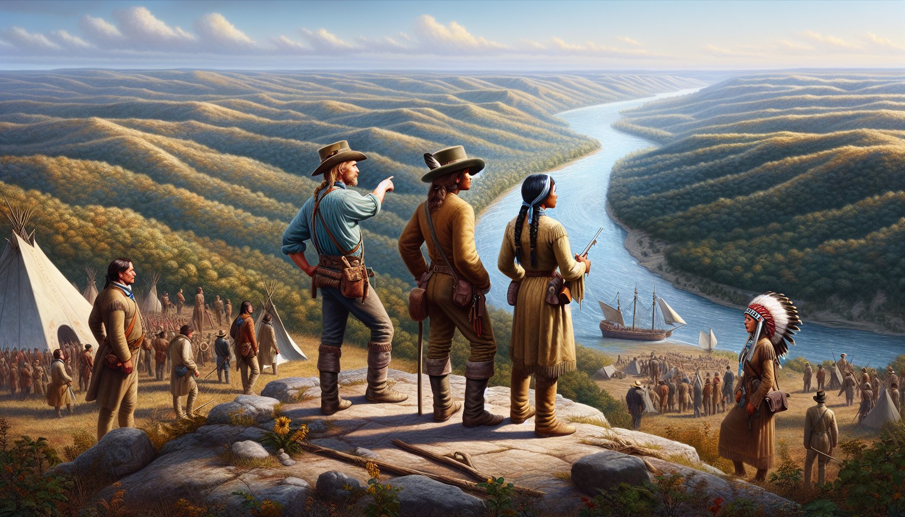
Delicate Diplomacy and Vital Alliances
The Lewis and Clark Expedition, despite its primary exploratory goals, rapidly evolved into a complex exercise in diplomacy and multicultural interactions. As the Corps of Discovery navigated the sprawling American frontier, they encountered numerous Native American tribes, each encounter demanding astute diplomatic engagement. The significance of these interactions cannot be overstated, as the success of their mission often hinged on the cooperation and goodwill of these indigenous populations.
The Role of Jefferson Peace Medals
One of the most emblematic tools of diplomacy employed by Lewis and Clark were the Jefferson Peace Medals. These medals were more than mere trinkets; they symbolized a gesture of peace and friendship towards the Native American tribes. Distributed as tokens of goodwill, the medals were integral in establishing initial trust. The tribes viewed these medals as a significant honor, a tangible acknowledgment of their importance and sovereignty. Lewis and Clark’s strategic distribution of these medals smoothed the path for negotiations and discussions vital to the expedition's progress.
Navigating Tribal Politics
The encounters with tribes such as the Shoshone, Mandan, and Nez Perce were not merely incidental; they were critical strategic elements of the expedition. For instance, the Shoshone Tribe, led by Chief Cameahwait who turned out to be Sacagawea’s brother, provided the expedition with horses and guides necessary for crossing the formidable Rocky Mountains. This alliance was pivotal, as without the horses, the passage through the rugged terrains would have been nearly insurmountable.
Moreover, the Mandan and Hidatsa tribes were essential during the winter of 1804-1805 when the expedition built Fort Mandan and hunkered down. The tribes not only provided shelter but also shared crucial survival strategies for the harsh winter conditions. Cultural exchanges during this period also enriched the Corps of Discovery's understanding of local customs and societal structures, which were meticulously documented in their journals and later provided invaluable insights into the region's ethnography.
Sacagawea – A Bridge Between Cultures
Sacagawea, the young Lemhi Shoshone woman, emerged not merely as a guide but as a vital diplomatic figure. Her presence with the expedition served as a symbol of peace to other tribes. Her ability to communicate in Shoshone and Hidatsa facilitated crucial dialogue and negotiations. Often, her mere presence alleviated potential hostilities, as her affiliation with the expedition signified a peaceful intent. Furthermore, her insights into the tribal geopolitics and landscape were indispensable.
Learning and Adapting to Tribal Etiquette
Lewis and Clark quickly learned the importance of respecting tribal etiquettes and protocols. Each tribe had its unique customs that the Corps needed to acknowledge and adhere to, in order not to offend their hosts. This adaptability not only prevented conflicts but also deepened their understanding of the diverse cultural landscapes of the American frontier.
In summary, the interactions with the Native tribes were not peripheral but central to the expedition. Through diplomatic savvy, backed by symbolic artifacts like the Jefferson Peace Medals, and crucial alliances with tribal leaders, Lewis and Clark navigated the complex social terrains of the American West. Their success in these engagements was a testament to their leadership and has left a lasting legacy on the historical narrative of the Lewis and Clark Expedition. The delicate diplomacy practiced during these encounters laid foundational stones for future relationships and set precedents in dealing with indigenous populations during westward expansion.
Scientific Discoveries and Documentation
The Lewis and Clark Expedition, a monumental journey initiated under the guidance of President Thomas Jefferson following the Louisiana Purchase, not only stretched the physical boundaries of the United States but also greatly expanded the contemporary knowledge of the natural world. Primarily tasked with exploration and cartography, Meriwether Lewis and William Clark also assumed the role of natural historians, documenting a remarkable diversity of flora and fauna across the American landscape.
Cataloging New Species
Meriwether Lewis's meticulous notes and sketches detail hundreds of plant and animal species previously unknown to science. This effort in botany and zoology was pivotal, shaping subsequent scientific studies in America.
- Plants: Notable examples include the Osage orange and camas root.
- Animals: Key animals documented include the prairie dog and grizzly bear.
This documentation was not just a cataloging effort but a comprehensive study that included observations of habitats, behaviors, and uses among the Native American tribes.
Contributions to Cartography
Alongside their natural history studies, Lewis and Clark's maps significantly altered geographical perspectives.
- Navigational Tools: Employing rudimentary yet effective tools, they provided the first accurate depiction of the interior regions of the continental United States.
- Detailed Routes: Their maps detailed the course of the Missouri River, navigated through the Rocky Mountains via the Lemhi Pass, and extended to the mouth of the Columbia River.
- Contributions from York and Sacagawea: York, an enslaved African American, alongside Sacagawea’s assistance, contributed substantially through labor and acute observations, enriching the maps' detail.
Interactions with Native Tribes and Botanical Contributions
Throughout their voyage, Lewis and Clark engaged extensively with various Native American tribes.
- Tribes such as the Shoshone and Mandan: Introduced them to numerous plants and their uses.
- Ethnography and Botany: This shared knowledge was prominently featured in the expedition’s journals, blending ethnography with botanical discoveries.
Sacagawea played a critical role in these interactions, aiding in identifying and gathering edible plants, which sustained the Corps of Discovery and provided samples like the camas root, detailed in their records.
Zoological Insights
The expedition also made crucial zoological discoveries.
- Key Observations: Notable insights include the behavior and environment of species like the bison and the grizzly bear.
- Interaction with Local Fauna: Lewis's Newfoundland dog, Seaman, provided an extra layer of interaction with wildlife, observed in encounters between the dog and local fauna.
The systematic documentation spearheaded by Lewis and Clark, under the directive of scientific discovery mandated by President Thomas Jefferson, laid foundational knowledge that propelled further explorations and studies. Their work remains a pivotal chapter in the nexus between exploration and science in early American history, underscoring the intertwined paths of geographic and scientific exploration.
Challenges and Obstacles
Embarking on the Lewis and Clark Expedition was no walk in the park—a journey filled with unforeseen challenges and demanding obstacles that tested the Corps of Discovery at every turn.
Navigational Difficulties
One of the most grueling aspects was navigating the diverse and often unforgiving terrains of the American frontier. The expedition utilized a variety of navigational tools and vessels including:
- Keelboat and Pirogues: Essential for traversing the Missouri River.
- Navigational Tools: Vital in managing the rivers fraught with sandbars and strong currents that threatened their watercraft.
Crossing the Rocky Mountains proved particularly taxing, nearly insurmountable without the aid of Native guides like Sacagawea, who was instrumental on multiple fronts:
- Guide Through Tough Terrain: Assisting with navigation and gathering essential resources.
- Provision Gathering: Her knowledge in foraging for edible plants like camas root was crucial for survival.
Navigating through the Bitterroot Mountains was another steep challenge:
- Harsh Terrain: Even the hardiest horses procured from the Shoshone struggled.
- Severe Conditions: The climbers faced biting cold, and food scarcity was patched occasionally with hunting successes, feasting on buffalo or bear oil when provisions ran low.
Conflict and Resolution
Human conflicts also posed significant hurdles. Their encounters with various Native American tribes could have derailed the mission but were often navigated with diplomacy and, when necessary, through sheer luck.
- Teton Sioux Conflict: This encounter threatened to turn violent over demands for one of the boats as a toll for passage. It was resolved through careful negotiation and the strategic use of Jefferson Peace Medals.
- Group Dynamics: Managing relationships within the group was crucial. York, Clark’s slave, played a pivotal role in hunting and scouting but faced challenges due to his status, often being underrecognized and undervalued.
Each day brought its set of trials, from the threat of grizzly bears to the ordeal of paddling upstream in adverse conditions. Despite these challenges, Lewis and Clark managed to:
- Chart Maps: Mapping the unknown territories.
- Compile Observations: Gathering valuable ethnographic and natural history observations.
- Foster Relationships: Establishing connections with Native tribes, which paved the way for future explorers and settlers.
Each struggle, while daunting, carved a path that greatly contributed to the mapping and understanding of the vast American West, permanently etching the names of Lewis and Clark in the annals of American history.
Legacy and Impact
Expansion of Knowledge
Through the arduous and daring exploits of the Lewis and Clark Expedition, a previously unclear image of the vast American frontier came into sharper focus. The duo's mapping efforts, largely considered mammoth feats at that time, played a pivotal role in expanding the geographical knowledge of the early 19th-century United States. These maps were not just topographical marvels but also integrated detailed encounters and observations, providing an unprecedented peek into the Western landscapes that seemed tantalizingly alien to the federal authorities and the common populace back East.
Moreover, the expedition significantly contributed to natural history through meticulous documentation of numerous plant and animal species previously unknown to science. The discovery of creatures like the grizzly bear and new plant species like the Osage orange enriched the scientific fabric of America and enhanced understanding about biodiversity of the West.
Effect on Native Communities
Despite its accolades in exploration and scientific contributions, the expedition was not without its profound impacts on the Native American tribes it encountered. Interaction with different tribes such as the Shoshone, Hidatsa, and Nez Perce varied from trade and assistance to tensions and conflicts. The expedition's need for guides, translation, and sustenance led to significant dependence on Native tribes, which altered the course of these communities through new alliances and dependencies formed.
Nevertheless, the arrival of the Corps of Discovery marked the beginning of increased intrusions by European settlers into Native lands, driven by the visions of manifest destiny and western expansion sowed by reports and journals from the expedition. This intrusion often culminated in a detrimental shift for many native communities, who faced increased pressures from settlers and subsequent loss of territories.
The journey of Lewis and Clark was, without a doubt, a monumental chapter in American history, marking the dawn of expanded Western explorations. However, it was also a prologue to the ensuing decades of profound transformation for the indigenous cultures that had thrived on these lands for centuries. As such, the legacy of the Lewis and Clark Expedition is a tale of dual narratives – one of monumental achievement and profound technological and cartographic progression, and another of cultural upheaval and the complex interactions between emergent American policies and the continent's original inhabitants.
In sum, the Expedition did far more than chart unknown territories – it set the course for the nation’s expansion westward, shaping the geopolitical landscape of modern America while casting long shadows over its native peoples.
Preserving the Journey
Diving into the meticulous efforts of the Lewis and Clark Expedition to document their monumental journey, one is struck by the sheer importance of journal keeping. Throughout the arduous trek from 1804 to 1806, both leaders, Meriwether Lewis and William Clark, alongside other members of the Corps of Discovery, embraced the discipline of daily record-keeping. The diaries served not just as personal logs but as essential tools for scientific and geographic documentation that would later prove indispensable to historians and scientists alike.
The expedition's journals, meticulously penned in often harsh and unforgiving conditions, contained rich descriptions of the landscapes, flora and fauna, and detailed accounts of the numerous encounters with Native American tribes. Beyond the geographical and ethnographic insights, these journals also recorded the daily challenges of expedition life, from navigational puzzles across the Continental Divide to critical interactions with indigenous peoples, painting a vivid picture of the perilous journey.
Today, these historic trails and sites are revered, not only as a testament to early American exploration but also as cultural landmarks significant to both the United States' heritage and several Native American histories. The Lewis and Clark Trail Heritage Foundation, along with various state and federal agencies, works tirelessly to preserve these paths. Efforts include marking significant sites along the route, such as Fort Mandan and Fort Clatsop, where the explorers spent grueling winters, and the various river passages that challenged the expedition from the Missouri to the Columbia River.
Public education initiatives have taken the forefront in these preservation efforts. Historical markers and visitor centers dot the extensive trail, providing educational materials and interactive experiences that bring the expedition's stories to life. These sites serve not only as reminders of past hardships and achievements but also as sources of inspiration for modern explorers and historians.
Moreover, advancements in digital archiving have enabled a more immersive approach to experiencing the Lewis and Clark Expedition. Digital replicas of original journal entries, maps, and drawings are accessible online, allowing a global audience to partake in the expedition from afar. These technological strides ensure that the legacies of Lewis, Clark, and the entire Corps of Discovery continue to educate and inspire, illustrating the unyielding human spirit of exploration and the relentless pursuit of knowledge about the natural world.
In preserving these paths and stories, we not only honor the memory of those who led one of the most significant explorations in American history but also ensure that the lessons gleaned from their experiences continue to influence and educate future generations. Through ongoing preservation efforts, the Lewis and Clark Expedition remains a key chapter in the epic narrative of American exploration and resilience, reminding us of the continuous need to explore, document, and preserve our shared history.


