By Emilia Wellesley · Published May 7, 2026 · Updated May 13, 2026
What People Mean by the Underwater City of Yonaguni
The phrase “underwater city of Yonaguni” is not a single object. It is an umbrella that has gathered, since 1985, a cluster of roughly ten distinct submerged features around the southern and northeastern coasts of Yonaguni-jima, the westernmost inhabited island of the Ryukyu archipelago. The phrase also names a discourse: the popular argument that these features together represent a sunken civic landscape, comparable in its imaginative weight to Atlantis or Mu, surviving as ruined geometry on a Pacific reef. The two senses are not the same. One is a list of places on a bathymetric chart. The other is a story about who might have lived along that chart’s contours when sea level stood roughly a hundred and twenty metres lower than it stands today.
This guide separates the two carefully. It walks across the broader submerged landscape around Yonaguni-jima, naming the sub-features that the popular literature has folded into the single phrase, and then sets the cluster against the comparative archaeology of the Sundaland shelf, where a much larger drowned landmass has been reconstructed from genuine paleoenvironmental work. It traces the cultural history of how the post-1985 Japanese popular media moved from “interesting reef” to “lost city,” and it finishes by placing the Yonaguni discourse in the longer Atlantis-Mu-Lemuria taxonomy of speculative submerged-civilisation claims, locating the formation within the broader landscape of historical and archaeological mysteries.
The Submerged Landscape Around Yonaguni-jima
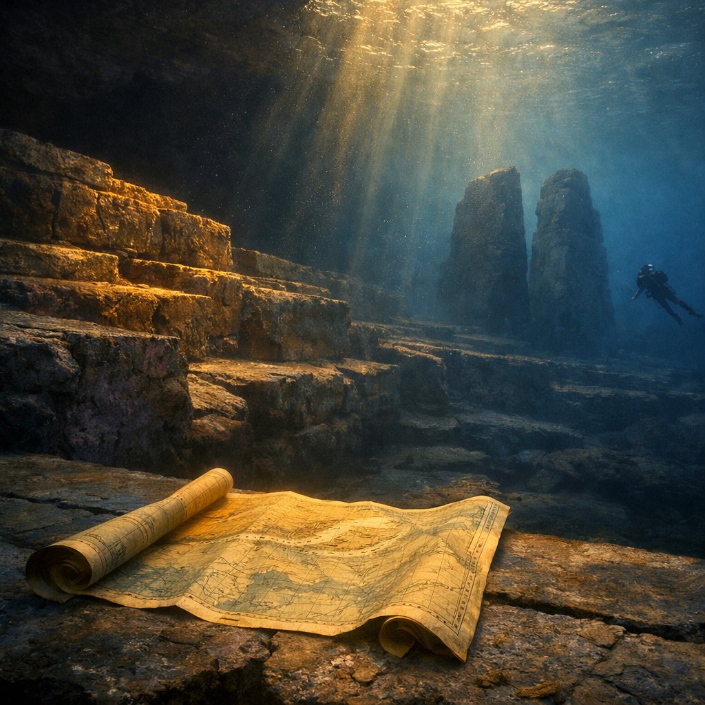
Yonaguni-jima is a small island, roughly twenty-eight square kilometres of basaltic and sedimentary terrain, but its submerged margins are extensive. The shelf around it falls in stepped benches that reach down to the deep East China Sea trough, and the Lower Miocene Yaeyama Group sandstone that dominates its coastal geology is exposed both above water and across long stretches of the underwater fringe. Marine geologist Masaaki Kimura (born 1940), who began surveying the island’s reefs in the late 1980s, eventually catalogued ten distinct feature clusters that the popular discourse has since folded into one composite “city” [1].
The Ten Feature Clusters Catalogued Since 1985
The most widely photographed feature is the Main Terrace, the stepped sandstone face off Arakawabana on the southern coast that diver Kihachiro Aratake reported in 1986. Beyond it lie what Kimura’s surveys have labelled the Stadium, a broader amphitheatre-shaped recess; the Triumphal Arch, a tall standing slab read in the popular literature as a ceremonial gate; the Turtle Stone, a weathered relief that resembles a turtle’s shell; the Twin Megaliths, a paired pair of upright slabs near the deeper end of the southern complex; the Loop Road, a curving channel that Kimura interpreted as an engineered passage; and the Stage, a flat raised plateau cut by linear depressions [1]. A short way to the northeast lies the Tatsumi-iwa formation off Tategami, a separate stepped face that local divers have surveyed since the early 1990s. Further still, a series of features near the main island of Okinawa, including the so-called Chatan Circles, were folded by Kimura into what he eventually called a regional submerged complex of fifteen sites stretching across the Ryukyu shelf [2].
How the Popular Discourse Folded the Cluster Into One City
The folding happened by stages. Aratake’s 1986 photographs of the Main Terrace circulated in Japanese diving media within the year. By 1992 the marine science journalist Kennosuke Nakamura had run a feature in Marine Diving that named the cluster “the underwater ruins of Yonaguni.” The phrase 海底遺跡, kaitei iseki, “submerged ruin,” entered the wider Japanese lexicon. By 1995 the popular author Joji Kaneda had published Yonaguni Kaitei Iseki, the first book-length treatment, which compressed the ten feature clusters into a unified civic landscape [3]. The feature clusters were never deposited as a single chart of related buildings. They were assembled, retrospectively, into a narrative of one. That distinction is what the geological reading and the popular reading have since been arguing about.
The Geological Floor: Why the Sandstone Looks Built
The host lithology under all ten of the named features is the same: medium to very fine sandstone of the Lower Miocene Yaeyama Group, deposited about twenty million years ago in a shallow marine setting and now exposed both onshore and offshore around Yonaguni-jima. Robert M. Schoch (born 1949) of Boston University, who first dived the southern complex in 1997, has consistently described what he found as a textbook case of jointed sandstone weathering. The Yaeyama Group sandstone shows two near-orthogonal joint sets and clear bedding planes, and where this rock is wave-cut along a slowly transgressing coast, the resulting blocks have flat tops, vertical sides, right-angle corners, and stair-like risers as a matter of basic structural geology [4]. The same pattern is visible above water in dry exposure on Yonaguni’s northeastern shoreline at Sannai-bana and Tategami, where no diver has ever proposed that an ancient stonemason was at work.
The Sea-Level Record Across the Last Glacial Maximum
The geomorphological reading sharpens when the sea-level history of the western Pacific is laid alongside it. During the Last Glacial Maximum, around twenty thousand years before present, ocean levels in this region stood roughly one hundred and twenty metres below their present mean. Patrick D. Nunn (born 1955), professor of geography at the University of the Sunshine Coast and the leading authority on Pacific Holocene sea-level history, has reconstructed the Holocene transgression in several pulses, with stand-still levels lasting centuries at a time [5]. Each stand cut a wave platform; each subsequent rise preserved that platform and began carving the next. The eventual underwater record is a staircase of terraces, of which Yonaguni’s Main Terrace and Tatsumi-iwa face are simply the best-preserved local examples.
Sundaland: The Comparative Drowned Landscape
If the Yonaguni discourse asks whether a single coastal cluster might preserve the geometry of a sunken settlement, the comparative archaeology of Southeast Asia asks the same question at the scale of an entire subcontinent. Sundaland is the now-submerged shelf that, at the height of the last glaciation, connected peninsular Malaysia, Sumatra, Java, and Borneo into a single landmass roughly one and a half times the present area of the Indian subcontinent. Its existence is not contested. It is reconstructed from bathymetric charts, paleo-river drainages, pollen cores, and faunal evidence drawn from cave deposits across the surviving islands [6].
Stephen Oppenheimer and the Eden in the East Hypothesis
The most ambitious popular treatment of the submerged landscape is geneticist Stephen Oppenheimer’s Eden in the East: The Drowned Continent of Southeast Asia (Phoenix, 1998), which argued that the Sundaland coast hosted some of the earliest agricultural and proto-urban populations of the Holocene and that the post-glacial drowning displaced these populations into surrounding regions, carrying technologies and myths with them [7]. Oppenheimer’s specific claim, that flood myths across Eurasia preserve cultural memory of the Sundaland transgression, remains contested. His more durable contribution is the demonstration that a serious paleoenvironmental reconstruction of a drowned shelf is methodologically possible at all, given the right combination of bathymetric, palynological, and archaeological data.
Graeme Barker on the Agricultural Revolution
A more guarded comparative reading sits in Graeme Barker’s The Agricultural Revolution in Prehistory: Why Did Foragers Become Farmers? (Oxford University Press, 2006), which surveys the global archaeological evidence for early plant management and animal husbandry [8]. Barker treats the Sundaland shelf as a region where the pre-transgressive coast was very probably occupied by foraging populations engaged in incipient plant management, but he holds the question of any urbanism well open, and his treatment is a useful corrective against the temptation to import Oppenheimer’s bolder claims wholesale into the Yonaguni cluster. What Sundaland establishes, with proper rigour, is that the post-glacial transgression flooded human-occupied coasts across a vast region of the Pacific. What it does not establish, and Yonaguni does not establish either, is that any of those coasts hosted built civic complexes that survived submergence as recognisable architecture.
The Mu and Lemuria Echo in Japanese Pop Media
The popular framing of Yonaguni did not reach for Sundaland. It reached for Mu. The lost continent of Mu was the literary invention of the Anglo-American writer James Churchward, whose The Lost Continent of Mu (Ives Washburn, 1926) and its four sequels placed an advanced Pacific civilisation across a vast equatorial ocean that supposedly drowned in a single catastrophe. Churchward’s Mu had no geological foundation; the Pacific basin shows no evidence of a drowned continent at the relevant scale, and the bathymetric record will not accommodate one. The earlier Lemuria, proposed by the British zoologist Philip Sclater in 1864 to explain lemur distributions and folded by the theosophist Helena Blavatsky into her cosmology in The Secret Doctrine (1888), occupied a similar position in nineteenth-century occult literature [9].
The 1990s Tabloid Frame
When the Yonaguni Main Terrace photographs reached a wider Japanese readership in the early 1990s, the available popular vocabulary for “submerged ancient site in the Pacific” was already saturated with Churchward’s Mu. Tabloid weeklies including Mu magazine, founded in 1979 by Gakken and explicitly named after Churchward’s continent, ran cover features framing the Yonaguni cluster as a confirmed Mu remnant through the mid-1990s. The popular author Masaaki Kimura himself, in his earlier publications, occasionally allowed the Mu framing to coexist with his geological surveys, although he largely set it aside in his later academic work [1]. The 1997 Japanese television documentary Sekai Fushigi Hakken ran a Yonaguni-Mu episode that drew an estimated audience of fifteen million households. The episode is a good record of how thoroughly the lost-continent framing had been absorbed by mainstream Japanese popular culture by the late 1990s.
Why the Echo Matters as Cultural History
The Mu echo is worth taking seriously as cultural history even when its geological premises are not. It records how a real reef formation, photographed by a working dive operator in 1986, was absorbed within a decade into a much older Anglo-American occult literature about lost Pacific continents, and how that absorption then shaped the Japanese popular reading of the site for the next twenty years. The underwater photographer Richard Schiele, whose extensive image archive of the southern complex from 1999 onward circulated through both diving magazines and Mu-frame popular books, sits exactly on this hinge: his photographs are precise records of a sandstone reef, and they were also the visual material out of which a lost-city narrative was constructed [10]. The two registers are separable, but they are not separate.
The Atlantis Taxonomy of Submerged-Civilisation Claims
The Yonaguni discourse belongs to a longer taxonomy of speculative submerged-civilisation claims that includes Plato’s Atlantis, Churchward’s Mu, Sclater and Blavatsky’s Lemuria, the Bimini Road off the Bahamas, the supposed Cuban underwater city of Guanahacabibes, and the disputed structures off Mahabalipuram on the Indian coast. The taxonomy has structural features that recur across its examples. Each requires a coherent civilisation, a destruction event, and a cultural inheritance that survives the drowning in legend or migration. Each tends to attach itself to a real geological or archaeological feature whose ambiguous geometry can be read as architecture if the prior framing is in place. Each runs aground on the same set of demands: missing artefactual assemblage, continuity of the supposed blocks with the underlying bedrock, and absence of stratified cultural deposits within reach of the site.
Where Yonaguni Sits in That Taxonomy
Of the named cases, Yonaguni occupies a particular position. It has more genuine geological substance than Bimini Road, whose joint-set sandstone explanation is straightforward, but less than Mahabalipuram, where genuine Pallava-period temple foundations are known to extend below the present tideline. It has more ambiguous geometry than the Cuban Guanahacabibes claim, whose deep-water sonar returns have not been resolved at all, and less of a cultural inheritance frame than Atlantis, whose myth Plato wrote into the Timaeus and the unfinished Critias with explicit polemical intent. The Yonaguni cluster is, in the strict sense, a real submerged sandstone landscape that has been read as a city. It is not, on present evidence, a city.
Holding the Two Yonagunis Apart
There are two Yonagunis in the literature, and treating them as one collapses the discourse into noise. The first is the underwater landscape: the Main Terrace, the Stadium, the Twin Megaliths, the Tatsumi-iwa face, and the broader cluster of submerged Yaeyama Group exposures around the island, all of which are best read on present evidence as wave-cut sandstone formations carved by tens of thousands of years of post-glacial transgression. The second is the underwater city: a cultural artefact assembled in Japanese popular media between 1986 and the late 1990s, drawing on the older Anglo-American Mu literature and absorbing the photographic record of Aratake, Kimura, and Schiele into a unified civic narrative. Both Yonagunis are real things. Only one of them is on the seabed.
Reading the cluster carefully means letting the geological floor stand first: a Lower Miocene sandstone reef, deeply jointed, slowly drowned by a Pacific that rose in pulses across the Holocene. It also means honouring the cultural history of how that reef became a city in print and on television, and how the Mu framing, the Atlantis taxonomy, and the Sundaland comparative archaeology converged on it from very different directions. The reef does not need a built civilisation to be interesting. The discourse around the reef is interesting precisely because it shows how a real coastline, photographed in good faith by a dive operator in 1986, can become, within a single decade, the cover image of a magazine named after a continent that never existed.
Frequently Asked Questions
Is the underwater city of Yonaguni a real archaeological site?
The submerged sandstone cluster around Yonaguni-jima is real and well-documented. The “city” framing is a popular discourse rather than an archaeological classification. Neither the Japanese Agency for Cultural Affairs nor the government of Okinawa Prefecture classifies the cluster as a cultural artefact, and the geological consensus reads it as a wave-cut natural formation in Lower Miocene Yaeyama Group sandstone.
How many separate underwater features lie around Yonaguni-jima?
Masaaki Kimura’s surveys catalogue roughly ten distinct feature clusters around the southern and northeastern coasts of Yonaguni-jima, including the Main Terrace, the Stadium, the Twin Megaliths, the Triumphal Arch, the Loop Road, the Turtle Stone, and the Tatsumi-iwa formation, plus several minor outcrops along the wider Yaeyama shelf.
How does Yonaguni compare to the drowned landscape of Sundaland?
Sundaland is a properly reconstructed submerged shelf roughly one and a half times the present area of India, drowned by the post-glacial transgression and supported by extensive bathymetric, palynological, and faunal evidence. Yonaguni is a single small reef cluster within the same broader Pacific transgressive context, but with no comparable evidence of urban occupation.
What does Stephen Oppenheimer’s Eden in the East argue?
Oppenheimer’s 1998 book argues that the Sundaland coast hosted early agricultural and proto-urban populations whose displacement by the Holocene transgression carried technologies and flood myths into surrounding regions. The methodological framework is durable; the specific claim about urban populations remains contested in the comparative archaeological literature.
What is the lost continent of Mu and how is it linked to Yonaguni?
Mu is a Pacific lost continent invented by James Churchward in 1926 with no geological basis. Japanese tabloid media in the 1990s, including Mu magazine founded in 1979, absorbed the Yonaguni Main Terrace photographs into a Mu framework, producing the popular linkage that has shaped the lost-city discourse ever since.
Did Masaaki Kimura ever endorse the Mu hypothesis for Yonaguni?
Kimura’s earlier publications occasionally allowed the Mu framing to coexist with his geological surveys, but he largely set the framing aside in his later academic work. His mature position links the cluster to early Holocene coastal populations rather than to Churchward’s Pacific continent.
What is Robert Schoch’s geological assessment of the Yonaguni cluster?
Schoch, who first dived the site in 1997, reads the cluster as a textbook case of weathering on jointed Lower Miocene sandstone, with right-angle corners and stair-like risers produced by basic structural geology rather than by stonemasonry. His assessment appears in Voices of the Rocks (Crown, 1999) and Pyramid Quest (TarcherPerigee, 2005).
What did Patrick Nunn contribute to the debate?
Nunn’s Vanished Islands and Hidden Continents of the Pacific (University of Hawaii Press, 2009) and his earlier sea-level work reconstruct the Holocene transgression in the western Pacific in detail, providing the regional sea-level framework against which Yonaguni’s terrace heights make geological sense as wave-cut platforms preserved during stand-still phases.
Where does Yonaguni sit in the wider taxonomy of submerged-civilisation claims?
Yonaguni occupies a middle position. It has more genuine geological substance than the Bimini Road off the Bahamas but less archaeological substance than Mahabalipuram, where genuine Pallava-period foundations extend below the tideline. The cluster is a real submerged sandstone landscape that has been read as a city, not a city itself.
What is Richard Schiele’s role in the Yonaguni record?
Richard Schiele is an underwater photographer whose extensive image archive of the southern complex from 1999 onward circulated through diving magazines and Mu-frame popular books. His photographs are precise records of a sandstone reef and were also the visual material out of which the lost-city narrative was constructed.
Is there any artefactual evidence supporting the underwater-city reading?
No working artefactual assemblage has been recovered from the seabed adjacent to the cluster or from terrestrial surveys of Yonaguni-jima within the relevant time window. A built civic complex would be expected to leave cores, flakes, hammerstones, and food refuse somewhere in the catchment. The absence is consistent with a natural feature.
What would settle the underwater-city question definitively?
Three lines of evidence would together close the case: structural surveys showing detachment of supposed blocks from the underlying bedrock rather than continuous bedding, microstructural analysis showing tool marks at a working scale rather than joint-surface fracture textures, and a stratified cultural assemblage from the seabed or the adjacent shore. None of the three currently exists.
Why does the lost-city framing continue to circulate despite the geological consensus?
The framing circulates because it sits in a long Anglo-American and Japanese popular literature about lost Pacific continents that predates the 1986 discovery, because the right-angle joint geometry of the Yaeyama sandstone genuinely resembles built architecture at first sight, and because the cluster is photogenic in ways that reward dramatic narrative compression rather than careful geological reading.


