By Theodora “Theo” Marsh · Published May 8, 2026 · Updated May 13, 2026
Last reviewed: May 8, 2026.
Direct Answer: What Is the Yonaguni Monument, and Is It Built or Born?
The Yonaguni Monument is a submerged sandstone formation off the southern coast of Yonaguni-jima in Japan’s Ryukyu chain, discovered by sport diver Kihachiro Aratake in 1986. Marine geologist Masaaki Kimura argues it is a worked human structure roughly 10,000 years old; geologist Robert M. Schoch and oceanographer Patrick D. Nunn read it as natural sandstone weathered along bedding planes and joints. The evidence currently favors the natural reading, with human modification possible but unproven.
The First Time You See It
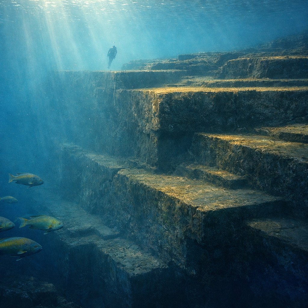
You enter the water off Arakawabana cliff, on the south coast of Yonaguni-jima, the westernmost island in the Ryukyu archipelago, closer to Taipei than to Tokyo. The current here is the Kuroshio, the warm western boundary current of the North Pacific, and it moves with the steady authority of a river that has forgotten the sea is supposed to slow it down. Hammerhead sharks pass through in winter; that is what brought Kihachiro Aratake, a local dive operator and director of the Yonaguni-Cho Tourism Association, to this stretch of seafloor in 1986 in the first place [1]. He was looking for sharks. He found right angles.
What he found, between five and twenty-five meters below the surface, is a rectangular mass of stone whose main terrace runs roughly one hundred and fifty meters long by forty wide, capped by a flat upper surface five meters under the swell [1][2]. The walls drop in clean steps. The corners are very nearly square. There are vertical shafts, narrow channels, a stone resembling a turtle’s shell from above, an arch divers swim through. There is a face the romantics call the Sphinx and the survey reports call a weathered protrusion. The first time you see it, in the green-blue light, with parrotfish drifting past your shoulder and the Kuroshio tugging at your fins, the impulse is immediate: someone built this. The harder question is whether the impulse is correct.
The site sits in open ocean, exposed to the full reach of the East China Sea on one side and the Pacific on the other. Visibility on a calm winter morning can reach thirty meters; in summer, when typhoons stir the bottom, it collapses to a green soup in which a diver can lose their bearings within a fin’s length. Most operators run the site from the small harbor at Kubura, on the island’s northwest coast, a twenty-minute boat ride around the western point. The local horses, the Yonaguni-uma, graze along the cliff road indifferent to whatever drama plays out below the waterline. The first European-language survey of the formation appeared in print only in the early 1990s, almost a decade after Aratake’s discovery, when Kimura’s research group began publishing detailed bathymetric maps and proposing the artificial-construction reading that would draw the international attention the site has carried ever since [5].
What the Stone Is Made Of
The monument is cut from the Yaeyama Group, an Early Miocene sequence of medium- to fine-grained sandstones interbedded with mudstones, deposited along this margin of the Eurasian Plate roughly twenty million years ago [1][2]. The same sandstones rise above the waterline a short swim away, in the Sanninudai slate cliffs at the south of the island, where they fracture into platforms and stair-step ledges that look uncannily like the ones underwater because they are the same lithology, behaving the same way [3]. That continuity matters. It is the first thing a working geologist will tell you to notice, and it tends to be the last thing visiting tour boats mention.
Sandstone of this kind splits along two structural weaknesses. The first is bedding: the horizontal planes laid down by ancient sediment, where the rock parts cleanly into slabs. The second is jointing: vertical fractures, often arranged in roughly perpendicular sets, produced by tectonic stress on a plate boundary that is still very much active. Yonaguni sits on the southern edge of the Ryukyu Trench, where the Philippine Sea Plate slides beneath the Eurasian. The 1771 Yaeyama Earthquake, with a moment magnitude estimated between 7.4 and 8.0, generated a tsunami whose run-up reached as high as forty meters on Ishigaki and killed roughly twelve thousand people across the southern Ryukyus [4]. The crust under Yonaguni breaks. It has always broken. The rectangles you see underwater are, in their honest geometry, the rectangles a rectangular mineral lattice produces when the earth shakes.
Kimura’s Argument: A Drowned City
Masaaki Kimura, a marine geologist long affiliated with the University of the Ryukyus in Okinawa, has spent decades arguing that the natural-jointing reading does not account for everything visible at the site [5]. He maps what he describes as a road, a stadium, gates, and a stepped pyramid; he reports tool-mark-like grooves, drilled-looking holes, and what he reads as relief carvings of animal forms and a humanoid face [5]. He has at various times associated the site with the legendary Yamatai polity of late prehistoric Japan and dated the monument to roughly ten thousand years ago, a period when the lower terraces would have stood above sea level during the late Pleistocene-to-Holocene transition [5][6].
The chronology has a real geophysical anchor. Sea level at the Last Glacial Maximum, about twenty-one thousand years ago, was on the order of one hundred and twenty meters lower than today; the upper surface of the monument, now five meters down, would have been dry land for thousands of years before global meltwater drowned it [6]. If a culture built terraces here in that window, those terraces would now be exactly where Kimura is looking. The hypothesis is internally consistent. Whether it is supported by the visible evidence is a separate question, and that is where the controversy actually lives.
What Kimura Points To
The features Kimura cites most often are the cleanness of the ninety-degree angles, the apparent regularity of the steps, the alignment of certain corridors with cardinal directions, the presence of features that resemble post-holes, and stones that to his eye have been moved from their original bedding orientation [5]. He reports finding loose blocks at the base of the structure that he interprets as fall debris from worked masonry. He describes a feature that resembles a stadium seating arrangement, a roughly square area he reads as a plaza, and a relief surface that under raking light seems to suggest a humanoid face. None of these observations are absurd; they are field notes from a credentialed marine geologist who has dived the site many times. The argument, in its strongest form, is that no single one of these features clinches the artificial reading on its own, but their cumulative density at one location is, in Kimura’s view, more than the natural-jointing model can account for [5].
Schoch and Nunn: The Natural Reading
Robert M. Schoch, a geologist at Boston University best known for his work on Egyptian weathering chronology, dove the site in the 1990s and published an analysis that has become the standard skeptical reading [3][7]. His central observation is that the monument is, throughout, a single mass of “living” bedrock. He found no evidence that any feature consists of separate blocks placed into position; the steps and walls are continuous with the rock beneath them. The Yaeyama sandstones, he wrote, contain numerous well-defined parallel bedding planes along which the layers separate easily, criss-crossed by sets of parallel vertical joints; weathering and wave action acting on this internal architecture will produce, predictably, exactly the rectangular forms a casual diver reads as architecture [3].
Patrick D. Nunn, professor of oceanic geoscience at the University of the South Pacific and a contributor to the Intergovernmental Panel on Climate Change reports, reaches a similar conclusion from a different angle [8]. Nunn points out that the underwater formations continue, without break, into the Sanninudai cliffs above the present waterline, where they have demonstrably been shaped by purely natural processes. Asking the underwater stretch to be artificial while the dry-land stretch is admitted as natural would require a discontinuity that no one has identified. Schoch is careful to add a nuance the popular coverage usually flattens: the question of artificial versus natural may not be all-or-nothing. A fundamentally natural formation could have been used, modified, or enhanced by people in deep antiquity, and that possibility is not refuted by the geological reading [3].
What the Authorities Say, and Don’t
Here the institutional record is its own kind of evidence. Neither Japan’s Agency for Cultural Affairs nor the Okinawa Prefectural Government has classified Yonaguni as an archaeological site of cultural importance, and neither agency has commissioned excavation or preservation work there [1]. National Geographic’s 2003 feature on the site quoted Kimura’s claims at length but framed the artificial reading as contested and noted the absence of corroborating archaeological evidence, including no portable artifacts, no stratified human deposits, no kiln debris, no shell midden, nothing of the kind that an inhabited terrace would leave behind [9]. That negative finding is not proof of natural origin, but it is the absence one would not expect if a city had stood here.
The institutional silence has frustrated proponents on both sides. Kimura has at times read the lack of official excavation as a refusal to engage with extraordinary evidence; skeptics tend to read it as a quiet acknowledgement that the necessary corroboration has not been produced. The Yaeyama region is, by any measure, archaeologically rich. Pottery sequences from neighboring Ishigaki and Iriomote document continuous human presence in the southern Ryukyus going back several thousand years, with shell middens, polished-stone tools, and a series of well-stratified coastal sites that would, in a comparable underwater context, be expected to produce some material evidence. The absence is more telling for what is missing than for what is theorized.
Standing in the Argument
When you surface from a Yonaguni dive and walk back along the road past the salt-cured horses of the Yonaguni-uma breed, the argument shifts. You can see, in the cliff face above the harbor, the same right-angled fracture geometry you have just swum across underwater. The local guides, who know the site better than any visiting researcher, will tell you both readings without choosing between them; they have learned that the site itself is the draw, and that it is honest enough to refuse to settle the question for anyone in a hurry. The dive briefings I have heard delivered on the boats out of Kubura harbor are admirably even-handed: they will name Aratake-san by family connection, walk you through the Kimura argument feature by feature, and then point to the Sanninudai cliffs above and tell you, in level voices, that the same stone above water has shaped itself the same way without anyone’s help. The wisest position to hold, on the present evidence, is the position the working geologists hold: the formation is natural, the geometry is real, and the human modification hypothesis remains in play but unsupported by independent archaeological corroboration. Anyone who tells you otherwise, in either direction, is overselling.
What the place teaches, in the meantime, is patience. The current keeps moving. The sandstone keeps splitting. The 1771 tsunami left coral boulders weighing up to two thousand five hundred tons stacked along the Yaeyama coastline, geological evidence that this corner of the Pacific has rearranged itself dramatically more than once in human memory [10]. Whatever the monument is, it is the visible edge of a much longer geological argument, one we are reading from a single chapter, in a language we are still learning.
Frequently Asked Questions
Who discovered the Yonaguni Monument?
Kihachiro Aratake, a local dive operator and director of the Yonaguni-Cho Tourism Association, located the formation in 1986 while scouting hammerhead-shark routes off the southern coast of Yonaguni-jima [1]. Aratake brought the site to wider attention through Japanese diving press; marine geologist Masaaki Kimura began surveying it shortly afterward.
How deep is the Yonaguni Monument?
The top of the main terrace lies roughly five meters below the present sea surface, and the structure descends to about twenty-five to twenty-seven meters at its base, with depths across the broader site ranging from five to about thirty meters [1][2]. Recreational divers typically work the upper terraces; deeper passages require advanced certification.
Is the Yonaguni Monument man-made?
The geological consensus, articulated most clearly by Robert Schoch and Patrick D. Nunn, is that the formation is natural, sandstone of the Miocene Yaeyama Group fractured along bedding planes and tectonic joints [3][8]. Masaaki Kimura’s contrary argument that it is a worked stepped monument has not been corroborated by independent archaeological excavation [1][5].
How old is the Yonaguni Monument?
The host rock, the Yaeyama Group, was deposited roughly twenty million years ago in the Early Miocene [1]. If the formation were artificial, Kimura’s chronology would place its construction near the end of the last Ice Age, about ten thousand years ago, when the upper terraces stood above sea level [5][6]. The natural-formation reading does not require a construction date.
What is the Yonaguni Monument made of?
It is composed of medium- to fine-grained sandstones and interbedded mudstones of the Early Miocene Yaeyama Group, the same lithology exposed in the Sanninudai cliffs immediately above the waterline at the south of Yonaguni-jima [1][3]. The continuity of rock type between the underwater and dry-land exposures is a key argument for natural origin.
Where exactly is the Yonaguni Monument located?
The site lies below Arakawabana cliff at the southern tip of Yonaguni-jima, the westernmost inhabited island of the Ryukyu archipelago, at approximately 24.4 degrees north latitude and 123.0 degrees east longitude, closer to Taiwan than to the Japanese main islands [1]. The main face of the monument is oriented south-southeast.
Why do some researchers think it is artificial?
Kimura cites the cleanness of the ninety-degree angles, the apparent regularity of the steps, what he reads as tool marks and post-holes, alignments of certain features with cardinal directions, and stones he interprets as having been moved from their original bedding orientation [5]. Critics respond that orthogonal jointing in tectonically stressed sandstone produces these features without human help [3].
Has the Japanese government recognized the site as a cultural heritage?
No. As of the most recent published reviews, neither the Japanese Agency for Cultural Affairs nor the Okinawa Prefectural Government classifies Yonaguni as a culturally important archaeological site, and neither agency has funded archaeological excavation or preservation there [1]. The absence of an official archaeological designation is itself part of the controversy.
Can tourists dive the Yonaguni Monument?
Yes. Local dive operators on Yonaguni-jima run organized trips to the site year-round, with the highest-visibility conditions usually in winter, when hammerhead-shark schools also pass through. The site sits in open water with strong Kuroshio currents, so most operators require advanced open-water certification and prior experience with current diving.
Is the Yonaguni Monument related to the Lost Continent of Mu or Atlantis?
Popular writers have linked the site to the Lost Continent of Mu hypothesis proposed by James Churchward and to the Atlantis tradition derived from Plato’s Timaeus and Critias. No peer-reviewed geological, oceanographic, or archaeological evidence supports either connection. The associations are speculative and lie outside the scientific debate [1].
What role did the 1771 Yaeyama Earthquake play in shaping the area?
The 1771 Yaeyama Earthquake, with an estimated moment magnitude between 7.4 and 8.0, generated the Great Meiwa Tsunami, with run-ups reaching forty meters on Ishigaki and killing roughly twelve thousand people across the southern Ryukyus [4]. Coral-boulder dating shows comparable tsunami events recurring in the region across at least two thousand years, evidence of repeated catastrophic reworking of the seafloor [10].
What do skeptical geologists say about the rectangular geometry?
Schoch’s published analysis emphasizes that the Yaeyama sandstones split along well-defined parallel bedding planes and are also crossed by parallel vertical joints; weathering and wave action acting on this orthogonal internal structure produces the rectangular blocks, terraces, and right-angled walls observed at the site without any human intervention [3]. The geometry is, geologically speaking, predictable.
What is the most honest takeaway from the Yonaguni controversy?
That a fundamentally natural formation can still feel architectural, and that the human eye is well-trained to read pattern into rectangular stone. Schoch’s nuance, that natural origin does not preclude later human modification, leaves the door open without overstating what we know. The honest position is to admit that the site is striking, the natural reading is well-supported, and the artificial reading remains an interesting hypothesis without independent corroboration.
Sources
- Wikipedia, “Yonaguni Monument,” en.wikipedia.org/wiki/Yonaguni_Monument.
- Megalithic Builders, “Yonaguni Monument, Yonaguni, Japan,” megalithicbuilders.com.
- Robert M. Schoch, “The Underwater Monument at Yonaguni, Japan,” robertschoch.com/yonaguni.html.
- Nakamura, M. (2009). “Fault model of the 1771 Yaeyama earthquake along the Ryukyu Trench estimated from the devastating tsunami,” Geophysical Research Letters, doi:10.1029/2009GL039730.
- Masaaki Kimura, “A Continental Shelf Phenomenon: Yonaguni Submarine Ruins,” University of the Ryukyus marine geology publications; English-language overview at en.wikipedia.org/wiki/Masaaki_Kimura.
- Lambeck, K., Rouby, H., Purcell, A., Sun, Y., and Sambridge, M. (2014). “Sea level and global ice volumes from the Last Glacial Maximum to the Holocene,” PNAS.
- Robert M. Schoch, “Enigmatic Yonaguni Underwater,” robertschoch.net.
- Patrick D. Nunn, Oceanic Islands (Blackwell, 1994), and University of the South Pacific publications on Pacific island geomorphology.
- National Geographic, “Japan’s Ancient Underwater ‘Pyramid’ Mystifies Scholars,” nationalgeographic.com.
- Araoka, D. et al. (2010). “Historic 1771 Meiwa tsunami confirmed by high-resolution U/Th dating of massive Porites coral boulders at Ishigaki Island,” Geochemistry, Geophysics, Geosystems, doi:10.1029/2009GC002893.
For broader context on submerged archaeological controversies, see our pillar on mystical places and lost worlds.
For broader exploration of mystical places and lost worlds, see Mount Everest: The Third Pole’s Mystical Aspects and Understanding Earth’s Energy Grid: Ley Lines and Vortexes.


