By Emilia Wellesley · Published May 5, 2026 · Updated May 13, 2026
Last reviewed: May 5, 2026.
What Happened to the Anasazi at the End of the Thirteenth Century?
Between roughly 1276 and 1300 CE, the Ancestral Puebloan communities living in the Four Corners region of the American Southwest abandoned the cliff-dwellings, kivas, and great houses that their families had built over preceding generations. The departure was not sudden, and it was not silent. Tree-ring dating, ceramic seriation, and the oral histories of the descendant Hopi and Zuni peoples each preserve a different angle on the same migration. Read together, they describe one of the largest population shifts in pre-contact North America.
The word “Anasazi” came into archaeological literature through Richard Wetherill in the late nineteenth century, who borrowed it from a Diné (Navajo) phrase often translated as “ancient enemies” or, less aggressively, “ancient ones who are not us.” Modern scholarship, including the National Park Service and most descendant-community publications, prefers “Ancestral Puebloans,” because it correctly attributes the architecture and culture to the ancestors of the present-day Pueblo peoples. The two terms appear together throughout this account because both are still in active use.
This is, in archaeological terms, a story of the transition from Pueblo III into Pueblo IV. It is also, as a question, a story about absence: the inhabited rooms emptied, the granaries left with corn still in them at sites like Long House on Wetherill Mesa, the kivas burned in carefully ritualized closures. Whether the people fled, were pushed, or moved according to a much older Pueblo cycle of migration is the working question. This account holds those possibilities open, where it can also be approached through the broader landscape of historical and archaeological mysteries.
Where the Ancestral Puebloans Lived Before They Left
By the middle of the thirteenth century, Ancestral Puebloan settlement reached its largest geographic spread. The Four Corners cultural region — where present-day Colorado, Utah, Arizona, and New Mexico meet — held tens of thousands of people across hundreds of villages, from small farmsteads on the Pajarito Plateau to dense aggregated towns in the Mesa Verde and Kayenta districts.
Mesa Verde: The Cliff-Dwelling Heart
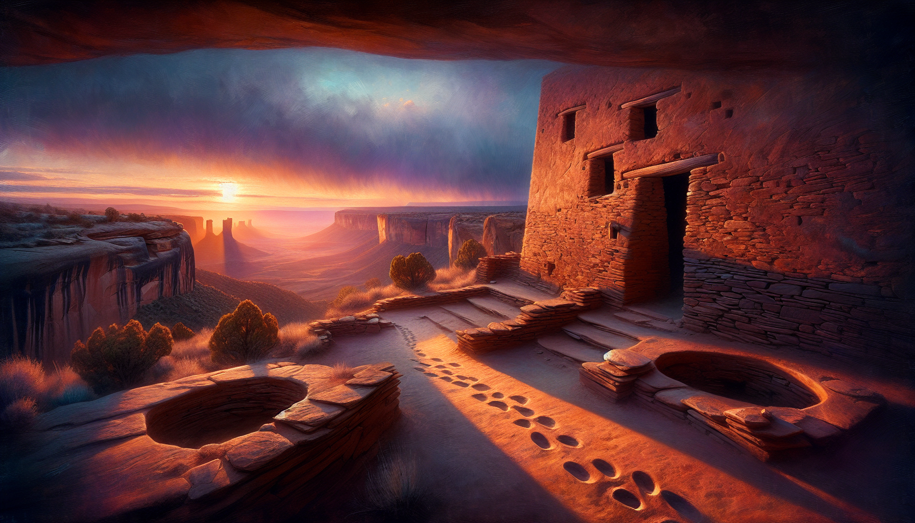
The Mesa Verde region in southwestern Colorado preserved the most architecturally dramatic phase of the late tradition. Cliff Palace, the largest cliff-dwelling in North America, contains roughly 150 rooms and 23 kivas tucked into a sandstone alcove, according to the National Park Service. Construction at Cliff Palace clusters in a narrow window between approximately 1190 and 1260, with the last datable beams cut in the 1280s. People moved into the alcoves late in the local sequence, suggesting that the spectacular architecture is also a defensive response to something happening on the open mesa-top above [1].
Chaco Canyon and Its Aftermath
A century before Mesa Verde reached its peak, the great houses of Chaco Canyon — Pueblo Bonito, Chetro Ketl, Pueblo del Arroyo — formed the ceremonial center of a regional system that radiated outward along engineered roads. Chaco itself depopulated by around 1150, and many scholars trace the late thirteenth-century disruptions to forces set in motion by Chaco’s earlier collapse. The archaeologist David E. Stuart, in Anasazi America (University of New Mexico Press, second edition, 2014), argues that the post-Chacoan population was structurally vulnerable: too dependent on a centralized exchange that no longer existed, too committed to a specific maize-bean-squash agricultural intensification to absorb a sustained climate shock [2].
Kayenta and the Western Pueblos
West of Mesa Verde, the Kayenta tradition produced its own dense aggregations at sites like Betatakin and Keet Seel in present-day northeastern Arizona. The Kayenta sequence ends at almost the same moment as Mesa Verde, in the 1280s and 1290s, but the migration vector was different. Kayenta people moved south and southwest, toward the Hopi Mesas and the Mogollon Rim, where their pottery types and architectural habits show up in receiving communities within a generation.
The Great Drought and the Tree-Ring Record
The strongest single piece of physical evidence for what happened in the Four Corners is dendrochronological. The University of Arizona’s Laboratory of Tree-Ring Research has assembled centuries of overlapping ring sequences from beams cut for Ancestral Puebloan construction. Those rings show a sustained drought from about 1276 to 1299 — sometimes called the “Great Drought” — overlapping a longer period of below-average precipitation that began earlier in the thirteenth century [3].
Reading the Rings
Tree rings are unsentimental. A narrow ring is a hungry year. The Mesa Verde and Kayenta sequences register a sequence of unusually narrow rings clustered through the last quarter of the thirteenth century, with little recovery in between. A maize-dependent population farming on the dry-farmed margins of viable rainfall would have faced consecutive harvest failures rather than a single bad year.
Why Drought Alone Is Not Enough
Earlier and equally severe droughts had hit the Ancestral Puebloan region without producing complete regional abandonment. The mid-twelfth century drought, which contributed to Chaco’s decline, drove rearrangement, not departure. The 1276-1299 episode coincided with social conditions that made adaptive moves harder: dense aggregation in defensible sites, depleted local soils after generations of intensive agriculture, and a population near the carrying capacity of dry-farming techniques. Drought set the conditions; it does not by itself explain the exits.
Evidence for Conflict in the Late Pueblo III Phase
Alongside the climate record, archaeologists working through the 1990s and 2000s recovered hard evidence of violence in the last decades before the regional departure. The picture is uneven, sometimes sensationalized in popular accounts, but the bone assemblages and burned structures cannot be argued away.
Castle Rock, Sand Canyon, and Cowboy Wash
Excavations at Castle Rock Pueblo and Sand Canyon Pueblo, both near present-day Cortez, Colorado, recorded large-scale destruction events dating to the 1280s. Crow Canyon Archaeological Center, which has worked the Mesa Verde region for more than four decades, documented unburied human remains, burned roof structures, and scattered weaponry consistent with sudden violent endings to occupation, summarized in their public-facing archaeology archives [4]. At Cowboy Wash, in the same general area, disarticulated remains showed cut marks and processing patterns that the principal investigators interpreted as cannibalism — a conclusion still debated, but no longer fringe.
Stephen LeBlanc’s Argument
The archaeologist Stephen H. LeBlanc, in Prehistoric Warfare in the American Southwest (University of Utah Press, 1999), argues that the late Pueblo III architectural shift toward defensive cliff alcoves, restricted access points, and high-walled compounds reflects a sustained period of intercommunity conflict, not a one-off raid. LeBlanc’s evidence is structural rather than anecdotal: village layouts in the late thirteenth century systematically prioritize defense over agricultural convenience [5]. Tim A. Kohler and colleagues, working with demographic models published in journals such as American Antiquity in 2010 and after, have shown that violent death rates in the Mesa Verde region rise sharply in the final decades of occupation [6].
Hopi and Zuni Testimony About the Migration
The descendant Pueblo communities have their own account of the departure, and that account does not describe a catastrophe. Hopi clan migration histories, recorded by ethnographers from Alexander M. Stephen in the 1890s through more recent oral-history projects led by Hopi scholars themselves, describe a sequence of movements that the clans understand as instructed and purposeful. Different clans took different routes. Some came up from the south, some from the east, some from the Four Corners alcoves, and they converged on the Hopi Mesas where their descendants live today.
Migration as Cultural Pattern
In the Hopi reading, leaving a place is part of how a Pueblo society stays Pueblo. The migration narratives describe communities completing what the land was meant to teach them, then moving on, leaving petroglyphs and ruined villages as a record of the lesson. The Zuni A:shiwi similarly preserve accounts of long migrations toward the “middle place” where Halona:Idiwana’a (Zuni Pueblo) now stands. The departure from the Four Corners, in this frame, is not an unsolved disappearance; it is a chapter in a known story.
Reading Both Records Together
Archaeology and Pueblo oral tradition are not in straightforward agreement, but they are also not as far apart as older accounts assumed. Both record movement of people, not extinction. Both place the destination of the late thirteenth-century migrants in the Rio Grande Valley, the Hopi Mesas, the Zuni country, and the Acoma area — exactly where Pueblo communities still live. The disagreement concerns cause and meaning. The archaeologist’s drought-and-conflict synthesis and the Pueblo migration narrative describe the same departure under different interpretive frames, and the careful researcher does not collapse one into the other.
From Pueblo III to Pueblo IV: Where Everyone Went
The Pecos Classification, the chronological framework most archaeologists still use for the Pueblo Southwest, places the regional departure at the boundary between Pueblo III (roughly 1150-1300) and Pueblo IV (roughly 1300-1600). Pueblo IV begins with an obvious population pulse southward and eastward.
The Rio Grande Pulse
In the early 1300s, large new towns appear along the Rio Grande and its tributaries — Tyuonyi, Kuaua, the Galisteo Basin pueblos. Many of these communities show ceramic and architectural signatures consistent with northern San Juan immigrants integrating with already-resident populations. The receiving region was not empty; the newcomers entered a social landscape and reshaped it.
The Hopi Mesas and the Western Refuge
Westward migrants consolidated on the Hopi Mesas and at Zuni and Acoma. Old Oraibi, on Third Mesa, has been continuously inhabited since approximately 1100, making it among the oldest continuously inhabited communities in North America. Hopi tradition holds that several of the late thirteenth-century clans arriving from the north and east are explicitly identified as descendants of Mesa Verde and Kayenta peoples [7].
What the Smithsonian and Crow Canyon Synthesize
Public-facing scholarship now treats the late thirteenth-century departure as multi-causal and partially understood, rather than as an unsolvable vanishing. The Smithsonian Magazine’s overview of late Anasazi research walks through the convergence of drought, social stress, and conflict that frames the current consensus, while leaving room for the migration interpretation that Pueblo communities themselves prefer [8]. Crow Canyon Archaeological Center has invested heavily in collaborative work with Hopi, Zuni, and Rio Grande Pueblo consultants, producing reports that cite descendant testimony alongside the radiocarbon and dendrochronology.
No single piece of evidence settles the question. A working synthesis might read: a long thirteenth-century climate decline tightened agricultural margins; aggregation into defensible sites concentrated risk; a final severe drought, layered onto food-stress and intercommunity conflict, made staying intolerable; existing Pueblo cultural patterns of clan migration provided the framework for organized departure; and the receiving regions absorbed the migrants and preserved their memory.
Why the Four Corners Departure Still Matters
The mystery is not that the Ancestral Puebloans disappeared, because they did not. Their descendants live in nineteen federally recognized Pueblo communities in New Mexico and Arizona, plus Hopi and Zuni, and they are present at the table when their ancestors’ sites are excavated. The mystery, more precisely, is how a people moved through a slow-motion catastrophe with enough cultural integrity that the receiving generations could carry the names of the abandoned places forward into a new century.
The Anasazi departure is one of the best-documented disappearances in North American archaeology because the descendants did the documentation themselves, in stone, in song, in ceramic styles that traveled with them. The careful researcher reads the rings, reads the burned roofs, reads the migration histories, and refuses to choose only one.
Frequently Asked Questions
Did the Anasazi really vanish?
No. They migrated. The descendants of the late thirteenth-century Four Corners population live today as the Hopi, the Zuni, the Acoma, and the nineteen Rio Grande Pueblo communities of New Mexico. The “disappearance” describes the abandonment of one region, not the end of a people.
Why is the term “Ancestral Puebloans” preferred over “Anasazi”?
“Anasazi” is a Diné (Navajo) word that descendant Pueblo communities did not choose for themselves and that some translate as “ancient enemies.” “Ancestral Puebloans” correctly identifies the population as the ancestors of the present-day Pueblo peoples. Both terms appear in current literature, but most public institutions, including the National Park Service, now lead with the descendant-preferred term.
What was the Great Drought?
The Great Drought is the dendrochronologically dated period of severe below-average precipitation in the American Southwest from approximately 1276 to 1299 CE, recorded in tree-ring sequences from the Laboratory of Tree-Ring Research at the University of Arizona. It overlapped earlier and longer-term climatic decline through the thirteenth century.
Was there warfare in the late Pueblo III period?
Yes. Sites including Castle Rock, Sand Canyon, and Cowboy Wash record evidence of violent destruction in the 1280s. Stephen LeBlanc’s Prehistoric Warfare in the American Southwest argues from architectural patterns that intercommunity conflict was sustained, not isolated. Demographic studies by Tim Kohler and colleagues show rising violent-death rates in the Mesa Verde region during the final decades of occupation.
Where did the migrants go?
Mesa Verde populations moved primarily into the northern Rio Grande Valley and the Galisteo Basin. Kayenta populations moved south and southwest to the Hopi Mesas and the Mogollon Rim. Both vectors are visible in early Pueblo IV ceramic styles and in Pueblo oral histories that name the source communities.
What is the Pecos Classification?
The Pecos Classification is the chronological framework for Ancestral Puebloan archaeology proposed at the 1927 Pecos Conference and refined since. It runs from Basketmaker II through Pueblo V, with Pueblo III ending and Pueblo IV beginning at approximately 1300 CE — the boundary marked by the Four Corners departure.
What does Hopi tradition say about the migration?
Hopi clan histories describe instructed, purposeful migrations rather than panicked flight. Different clans arrived at the Hopi Mesas from different directions, leaving petroglyphs and abandoned villages as a record of completed lessons. Old Oraibi on Third Mesa, continuously occupied since approximately 1100, was among the receiving communities.
Could climate change alone explain the departure?
Probably not. Earlier severe droughts in the same region produced rearrangement and not regional abandonment. The 1276-1299 drought hit a population that had already aggregated into defensible sites, depleted local soils, and pushed dry-farming to its limits. Climate set the conditions; demography, politics, and conflict shaped the response.
Where is Cliff Palace, and who built it?
Cliff Palace, the largest cliff-dwelling in North America, sits within a sandstone alcove in Mesa Verde National Park in southwestern Colorado. Tree-ring dates place its main construction phase between approximately 1190 and 1260, with the last datable timbers cut in the 1280s. Its builders were Mesa Verde Ancestral Puebloans whose descendants are among the modern Pueblo communities of New Mexico and Arizona.


