Ley lines are hypothetical straight lines connecting ancient landmarks, megaliths, and sacred sites across a landscape. The amateur archaeologist Alfred Watkins proposed them in 1921 as prehistoric trade routes; later New Age writers reimagined them as channels of earth energy. No scientific evidence supports either claim.
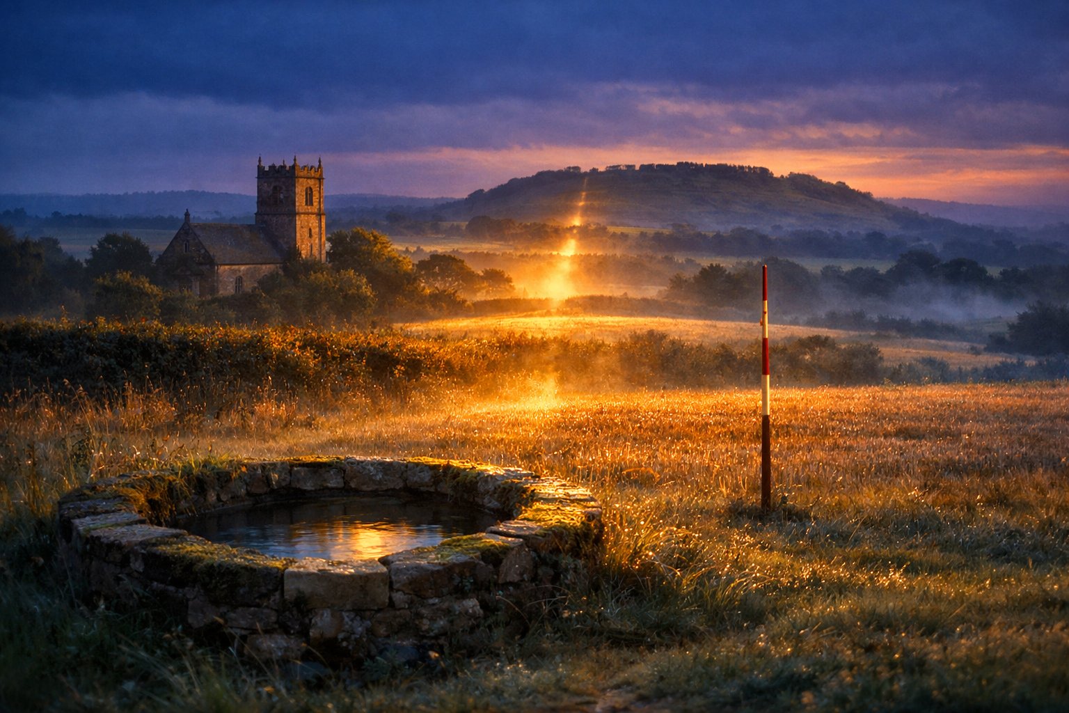
I have stood on a Herefordshire hill at the hour Watkins loved, the long light raking across the fields, and watched a church tower, a holy well, and a far ridge fall into a line so clean it felt argued rather than accidental. That feeling is the whole story of ley lines: the moment the land seems to speak in geometry, and the slower work of asking whether it actually did. What follows is a walk through that question, from a Hereford map table to the slopes of the Andes, with the field notebook open and the survey volumes within reach inside the wider world of mystical places and lost worlds.
Published: June 5, 2026. Last reviewed: June 5, 2026.
What Are Ley Lines?
Ley lines are hypothetical straight alignments drawn between landmarks such as stone circles, hilltop churches, and burial mounds, a concept the Herefordshire antiquarian Alfred Watkins introduced in 1921 and named after the Old English word for a woodland clearing. The word and the idea, it turns out, were a little at odds from the start.
According to Encyclopaedia Britannica, ley lines are invisible lines said to join significant landmarks across the world, a notion classed today as pseudoscientific and New Age rather than archaeological [1]. The supposed alignments link sites built across wildly different centuries, which is the first thing a historian notices and the last thing a believer mentions. A Bronze Age barrow, a medieval church, and a Victorian folly can all sit on the same drawn line, yet they were never contemporaries who could have planned it together [3].
Watkins borrowed the term from English place-names ending in -ley or -leigh, believing they marked his routes. The irony, which careful philologists pointed out, is that the Old English lēah means a clearing in woodland, not a straight track at all. The name preserves a misreading, even as it has outlived the theory that produced it. The idea gathered a devoted following all the same, and by the 1960s a network of amateur “ley hunters” was tramping the countryside with maps and straightedges, certain that the lines they traced recovered a forgotten national geometry.
Alfred Watkins and the Birth of the Ley
Alfred Watkins, a Hereford businessman, inventor, and amateur archaeologist, published The Old Straight Track in 1925, arguing that prehistoric Britons laid out a network of dead-straight trackways marked by mounds, moats, beacons, and standing stones. He was sixty-six, and he had spent a working life reading the countryside through a camera lens.
The idea arrived in a single afternoon. On a visit to Blackwardine in Herefordshire in June 1921, Watkins looked across the hills and saw, or believed he saw, a web of straight lines knitting the old sites together [2][3]. He first laid the case out in Early British Trackways (1922) and then fully in The Old Straight Track (1925), the founding book of ley hunting. As the art historians at Tate have shown, Watkins came to the landscape as a pioneering photographer, trained to notice how features stack and align in a flattened frame [4].
What deserves emphasis is how earthbound his theory was. Watkins claimed no magic. His leys were practical: sightlines for traders and travellers moving across a roadless country, marked by features a walker could aim toward. The British archaeological establishment rejected the claim in his lifetime, noting that no one walks dead-straight over hills and rivers when a contour-hugging path is easier [1][2]. The mysticism came later, and from other hands.
From Trade Routes to Earth Energy
John Michell transformed Watkins’s practical trade-route theory into a mystical one in his 1969 book The View Over Atlantis, recasting leys as channels of earth energy bound up with sacred geometry, dowsing, and even flying saucers. The book became a foundational text of the British counterculture and the global New Age that followed.
Two things get conflated here: Watkins’s surveyor’s lines and Michell’s energy lines are not the same idea wearing two coats. Watkins drew routes; Michell drew currents. By the late 1960s, the spiritual seekers of the New Age movement had stretched the concept past England and onto the whole planet, tying it to UFO sightings and a vocabulary of cosmic force [1]. Michell explicitly braided the British leys together with the Chinese lung mei, the “dragon lines” of feng shui, presenting straightness and earth current as a single worldwide tradition. A German precursor had already gestured this way: Wilhelm Teudt proposed heilige linien, or holy lines, around the Externsteine rocks in 1929, though specialists dismissed his work even then.
The energy claim invited testing, and to its credit it got some. Paul Devereux, then editor of The Ley Hunter, founded the Dragon Project in 1977 to measure magnetism, radiation, and ultrasound at megalithic sites. After roughly a decade of instruments and dowsers, the project found no consistent energy that would justify the theory, only scattered and unrepeatable readings [3].
How Ley-Line Thinking Evolved: A Timeline
The idea of ley lines passed through three distinct phases between 1921 and the present, drifting from practical survey to earth-energy mysticism and finally into statistical scrutiny. The chronology below tracks the figures and books that moved it from one to the next.
| Year | Figure or work | What changed |
|---|---|---|
| 1921 | Alfred Watkins, at Blackwardine | Leys first conceived as prehistoric trackways |
| 1925 | The Old Straight Track | The trade-route theory published in full |
| 1929 | Wilhelm Teudt, heilige linien | German “holy lines” parallel at the Externsteine |
| 1969 | John Michell, The View Over Atlantis | Leys recast as lines of earth energy |
| 1977 | Paul Devereux, Dragon Project | A decade of instrument testing begins |
| 1983 | Williamson & Bellamy, Ley Lines in Question | Randomization shows alignments arise by chance |
| 2010 | Matt Parker, Woolworths demonstration | Chance alignments shown with modern shops |
The St Michael’s Line and Britain’s Famous Alignments
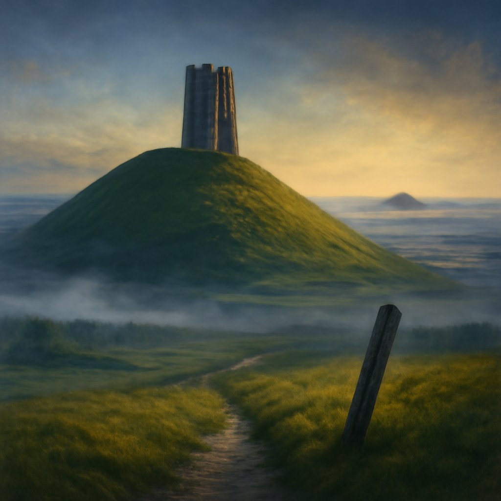
The St Michael’s line is the most famous of Britain’s claimed ley alignments, running across the widest part of southern England from St Michael’s Mount in Cornwall through Glastonbury Tor and Avebury toward the Suffolk coast. It strings together hilltops and churches dedicated to the dragon-slaying saint.
Standing at the site: from the top of Glastonbury Tor the land falls away on every side, and the ruined tower of St Michael holds the highest point like a marker someone meant you to find. John Michell traced this alignment, and later the dowser Hamish Miller and the writer Paul Broadhurst followed it on foot for The Sun and the Serpent (1989), describing two intertwining currents they named Michael and Mary [5]. The line is often said to track the Beltane sunrise, the May Day point on the horizon where the sun clears the eastern hills.
A local guide on the Tor once told me the alignment is real to the people who walk it, whatever a surveyor concludes, and that distinction is worth keeping. The places on this line, Avebury’s great stone circle, the Tor, St Michael’s Mount rising from its tidal causeway, are genuinely remarkable on their own merits [5]. Whether a single intentional thread connects them is the part the map cannot settle.
Ley Lines Around the World
New Age writers extended the ley concept worldwide after the 1960s, mapping global energy grids onto Earth and connecting sites such as the Pyramids of Giza, Machu Picchu, Stonehenge, and Uluru. The lines grew from a regional curiosity into a planetary claim.
The most elaborate version is the Becker-Hagens planetary grid associated with William Becker and Bethe Hagens, who projected an icosahedral lattice of energy nodes across the globe and matched its vertices to fault lines and famous monuments. In the United States, the red-rock town of Sedona in Arizona built a whole tourist economy on “vortexes” where ley lines are said to converge, complete with guides demonstrating dowsing rods that swing as you cross the supposed current.
Here the visitor-ethics question sharpens. Some genuinely ancient cultures did organize sacred space along lines, but on their own terms, not Watkins’s. The Inca ceque system radiated forty-one or forty-two lines and more than three hundred huacas, or shrines, outward from the Coricancha temple at the center of Cusco. Yet the archaeologist Brian Bauer found that these ceques mostly zigzag through the terrain rather than run geometrically straight, a finding that should caution anyone tempted to read every old sacred geography as a grid [8]. Borrowing Indigenous sites to decorate a Western energy map flattens traditions that deserve to be met on their own ground.
Do Ley Lines Hold Up? The Statistical Reckoning
Statisticians and archaeologists have demonstrated that a sufficiently dense scatter of random points reliably produces straight-line alignments by pure chance, which undermines the central claim that ley alignments reflect deliberate ancient planning rather than coincidence. The mathematics is unforgiving and, once seen, hard to unsee.
On the math: with tens of thousands of prehistoric features dotting England, three-point and even four-point alignments occur in the dozens or hundreds for purely random reasons. Tom Williamson and Liz Bellamy made the point sharply in Ley Lines in Question (1983) by randomizing the positions of points on an Ordnance Survey sheet covering Avebury and finding that the random scatter threw up as many “leys” as the real landscape did [6]. In 2010 the mathematician Matt Parker drove the joke home, showing that the locations of defunct Woolworths stores form crisp alignments, including an equilateral triangle around Birmingham, purely by chance [7]. The trick of the trade, Williamson and Bellamy noted, is that a generous alignment tolerance and a few physically large sites quietly inflate the count: widen the band a little and the same map yields twice as many leys, none of them designed [6].
The deeper problems are historical, not just statistical. There is no record that any ancient European society recognized ley lines as a concept, and the alignments connect monuments separated by thousands of years [1][3]. Drawn on a flat map, the lines also ignore the curvature of the Earth and the hills, forests, and rivers that a real traveller would have to cross [1].

Why We Keep Drawing the Lines
Ley lines persist not because the evidence supports them but because the act of connecting places answers a human need to read meaning into landscape. The impulse is older than Watkins and will outlast the debunking.
There is something honest in the original instinct. To walk from a barrow to a church to a hill-fort and feel them gathered into a shape is to practice a kind of attention that maps reward and screens dull. The error is not in the looking; it is in mistaking a pattern the eye composes for a plan the ancestors drew. The pleasure of a ridge that lines up with a steeple is real even when the ley is not.
So I keep the notebook and the survey volume both, and I let them disagree. The land does not need an invisible grid to be worth standing on; the standing-there is the point, and the meaning accrues in the feet and the slow looking rather than in the straight line. If you want to follow that looking further, the rest of our field notes on sacred geography and lost worlds begin where this one ends, and you can read more about the travel-historian behind them on Theodora Marsh’s author page.


