By Emilia Wellesley · Published May 5, 2026 · Updated May 13, 2026
Last reviewed: May 5, 2026.
What Machu Picchu Actually Is
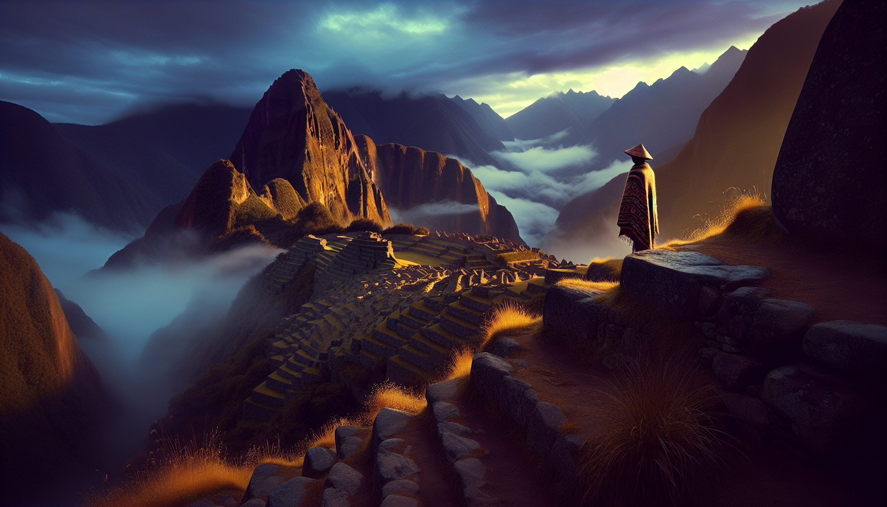
Machu Picchu is a fifteenth-century Inca royal estate built on a granite saddle between two Andean peaks in the Cusco Region of Peru, roughly 2,430 meters above sea level and about 80 kilometers northwest of Cusco. The complex was constructed during the reign of Pachacuti Inca Yupanqui (r. circa 1438-1471), abandoned within a century, and reintroduced to the world by Hiram Bingham in 1911. The phrase “Lost City” is rhetoric. The Spanish never reached it; Quechua-speaking locals never forgot it.
The site sits on a ridge that drops away on three sides into the Urubamba river gorge below. From that ridge the Incas cut terraces into the slope, carved water channels, and assembled walls of fitted ashlar masonry so close-jointed that a knife blade will not slip between the stones. They did this without iron tools, without mortar, and without the wheel.
This guide reads Machu Picchu the way an archaeologist reads a manuscript: for what is said, what is unsaid, and what survived only because of how it was discarded. It situates the site within the broader landscape of historical and archaeological mysteries, names the figures and texts that shaped its modern reading, and holds open the questions that the stones still refuse to settle.
The 1911 “Rediscovery” Was a Renaming
Hiram Bingham III (1875-1956), a Yale lecturer in South American history, climbed to the ruin on July 24, 1911, guided by a farmer named Melchor Arteaga and an eleven-year-old boy named Pablito Alvarez. He published the first photographs and a long account in the April 1913 issue of National Geographic, archived through the JSTOR record of the issue [1]. The image of a vine-choked citadel emerging from cloud forest entered Western imagination almost overnight.
The “discovery” framing collapses on inspection. Quechua families had been farming the lower terraces for at least two generations before Bingham arrived. A Cusco-born landowner named Agustin Lizarraga had carved his name onto a wall in 1902. Bingham’s contribution was not finding the stones but introducing them to a global audience equipped with cameras and a museum partnership at Yale’s Peabody Museum, where his collection of skeletal remains and ceramics was archived for nearly a century before its 2011-2012 repatriation to the Universidad Nacional de San Antonio Abad del Cusco [2].
Pachacuti’s Royal Estate, Around 1450
The most widely accepted reading of the site, advanced by the archaeologist Richard L. Burger and the bioarchaeologist Lucy C. Salazar in their 2004 Yale volume Machu Picchu: Unveiling the Mystery of the Incas, identifies Machu Picchu as the private royal estate of Pachacuti, the ninth Sapa Inca and the sovereign credited with the empire’s expansion from a single highland valley into the largest pre-Columbian state in the Americas [3]. Estate-building in the Inca world worked differently from European feudal models: the property belonged to the deceased emperor’s panaqa, the lineage that maintained his cult, his mummified body, and his rituals of state, rather than to a successor.
Three lines of evidence converge on the Pachacuti reading. Sixteenth-century Spanish chronicles, especially the Relacion de los quipucamayos compiled around 1542, name a royal property called Picchu among Pachacuti’s holdings. Radiocarbon dates from organic remains across the site cluster between roughly 1420 and 1530. And the bioarchaeology of the burial population, drawn from the Yale collection, points to a small permanent retainer staff of mixed regional origin, exactly what an estate would require.
Why an Estate Looks Like a City
The reason Bingham reached for “Lost City” was that Machu Picchu has the morphology of a town: residential blocks, plazas, a central kiva-like sunken court, agricultural terracing sufficient to feed a population, and a clear ceremonial precinct. An Inca royal estate housed a court in miniature, including masons, weavers, priests, astronomers, agricultural specialists, and the women called aclla who tended the cult of the Sun. The settlement housed perhaps 500 to 750 people in residence, swelling for festivals. The “city” reading is not wrong about the population. It is wrong about the function.
How the Stone Was Cut
The most-asked question about the site is the simplest to state and the hardest to fully answer: how were the largest blocks shaped to such tolerances that a credit card cannot enter the joints? The short answer is that Inca masons used harder stone to dress softer stone. Granite was shaped with hammerstones of an even harder rock, often basalt or quartzite, in a slow process of percussion, abrasion, and trial fitting. According to the UNESCO World Heritage Centre’s site dossier, no metal tools have ever been recovered in association with the dressed surfaces themselves [4].
Two construction grades coexist at Machu Picchu. Lower-status walls use pirca, a fieldstone-and-clay technique still seen in Andean villages today. The high-status walls in the Temple of the Sun and the Royal Mausoleum use polygonal ashlar masonry, in which each block is cut with multiple irregular faces to lock against its neighbors without right angles. This is the construction style that has survived more than a dozen significant earthquakes since the fifteenth century with negligible structural damage. The blocks settle into each other under seismic load and return to position when the shaking stops, a passive damping behavior that modern engineers have modeled and respected.
The Ashlar Argument
A persistent strand of popular writing argues that polygonal ashlar requires a lost technology. The archaeological record does not support that reading. Quarries adjacent to the site preserve partially dressed blocks at every stage of completion, and ethnographic work with Quechua masons recovered a continuous tradition of percussion shaping. The work was extraordinarily labor-intensive, and the empire could afford it. What looks like impossibility is the visible signature of the mit’a rotational service that kept the Inca state moving.
Ritual Function: Ushnu, Intihuatana, and the Sacred Geography
Even within the estate reading, the site retains a strong ritual signature. The Intihuatana, a carved stone outcrop on the highest platform, has been read since the early twentieth century as a horizon-calendar device, possibly an ushnu in the broader Inca sense: a ritual stone where the Sapa Inca channeled offerings to the sun, the earth, and the apus, the mountain spirits. The Temple of the Sun, with its precisely oriented eastern window, admits the rising sun on the June solstice through a single aperture onto a carved altar. The Room of the Three Windows, sited above the central plaza, frames a triple horizon vista of the eastern range that aligns with seasonal markers documented in colonial-era chronicles.
The Britannica entry on Machu Picchu summarizes a generation of consensus: the estate functioned as a place where the emperor’s lineage performed the calendrical rituals required to keep the empire’s agricultural and political year in balance [5]. Whether Pachacuti himself ever lived there for sustained periods is unclear. What is clear is that the rituals had to be performed somewhere, and a high, defensible, beautiful site with sightlines to a constellation of named sacred peaks was the kind of place an Inca court would choose.
Why It Was Abandoned
Machu Picchu was occupied for roughly a century, then quietly emptied. The most rigorous reconstruction, drawing on John Hemming’s The Conquest of the Incas (1970), holds that the abandonment correlates with the Spanish invasion of 1532 and the smallpox epidemic that preceded it by a few years. The estate’s labor force, drawn from across the empire under the mit’a system, would have been recalled, killed, or scattered. The site itself was never sacked, never burned, and never named in Spanish colonial records, an absence that strongly suggests Spanish administrators never knew it existed. Forest reclaimed it within a generation. The locals who continued to farm its lower terraces had no reason to advertise the upper ruin to outsiders, and the upper ruin had no reason to attract them.
The Open Question
Scholarship since the 1980s has narrowed the interpretive options without closing them. Was Machu Picchu primarily a royal retreat, a ritual observatory, or a strategic frontier outpost on the edge of the Amazon-facing montana? The Burger and Salazar reading favors the retreat-with-ritual function. Other Andean specialists, including Johan Reinhard in his 1991 study of Inca sacred geography, emphasize the observatory-and-pilgrimage dimension. A minority view treats the site as a strategic node controlling access to coca-growing lowlands. The evidence does not yet force a single answer. The honest position is to hold all three open and to note what new finding would distinguish them: a written reference in a colonial archive, an unambiguous storeroom inventory in the bioarchaeology, or a defensive feature inconsistent with peacetime use.
What Survived, and What That Means
Machu Picchu was inscribed as a UNESCO World Heritage Site in 1983 under both cultural and natural criteria, and the Smithsonian’s coverage of the centennial of Bingham’s visit reframed the site as a case study in how academic claim-making intersects with national patrimony [6]. The Yale-Peru repatriation agreement signed in 2007 and the return of more than 40,000 fragments to Cusco between 2011 and 2012 changed the institutional geography of Machu Picchu studies. Future scholarship will be done in Peru, by scholars trained in Peru, with the human remains held in Peru. The interpretive frame is shifting in that direction whether or not English-language readers notice.
What endures, beyond the photographs and the visitor numbers, is the discipline of the work itself. The Incas built a place where solstice light still enters a window cut for it, where stones still hold against earthquakes that have flattened modern buildings, where terraces still drain after centuries of monsoon. The stones are not in a hurry. Neither were the people who set them.
Frequently Asked Questions
Is Machu Picchu actually a “lost city”?
No. The “Lost City” phrase is rhetorical framing introduced by Hiram Bingham in 1911 and carried by his 1913 National Geographic coverage. The Incas abandoned the site after the Spanish invasion of 1532, but Quechua-speaking families continued to live nearby and to farm its lower terraces. The Spanish never reached the site, never wrote it into colonial records, and never destroyed it. Local people knew exactly where it was.
Who built Machu Picchu and when?
The site was built by the Inca state during the reign of Pachacuti Inca Yupanqui, beginning around 1450. Radiocarbon dates from organic remains span roughly 1420 to 1530, consistent with mid-fifteenth century construction and a century of occupation before abandonment.
Was Machu Picchu a city, a temple, or something else?
Most archaeologists today treat it as a royal estate of Pachacuti, owned by his descent group rather than by a successor king. The estate housed an in-residence population of about 500-750 people, including masons, priests, astronomers, and ritual specialists. It performed ceremonial, residential, and agricultural functions simultaneously.
How did the Incas cut the stones so precisely?
Inca masons used harder stones, often basalt and quartzite hammerstones, to dress softer granite blocks by percussion and abrasion, with repeated trial fitting against neighboring stones. The polygonal ashlar masonry of the high-status walls locks irregularly faced blocks together without mortar. No metal tools have been recovered in direct association with the dressed surfaces.
Why is the masonry earthquake-resistant?
The polygonal ashlar walls behave as passively damped structures. Under seismic load the blocks shift slightly, dissipating energy through friction at the joints, and resettle into position when the shaking stops. The walls have weathered more than a dozen significant earthquakes since the fifteenth century with negligible damage.
Why was Machu Picchu abandoned?
The most defensible reconstruction ties the abandonment to the Spanish invasion of 1532 and the smallpox epidemic that preceded it. The estate depended on rotational labor drawn from across the empire; once that system collapsed, the site lost its supporting workforce. The forest reclaimed it within a generation.
What is the Intihuatana stone?
The Intihuatana is a carved granite outcrop on the highest platform of the site, often described as a “hitching post of the sun.” It functioned as a horizon-calendar device, possibly an ushnu, where the Sapa Inca made offerings to the sun, the earth, and the surrounding mountain spirits, the apus.
How did Hiram Bingham find the site?
A local farmer named Melchor Arteaga led Bingham up the ridge on July 24, 1911. An eleven-year-old Quechua boy, Pablito Alvarez, guided him onto the actual ruins. Bingham’s contribution was global publication, especially the April 1913 issue of National Geographic, not first sighting. Local people had farmed the lower terraces for generations.
Where are the artifacts Bingham removed?
Bingham’s collections, including ceramics, metalwork, and roughly 174 sets of skeletal remains, were held by Yale’s Peabody Museum from 1912 onward. After a 2007 agreement, more than 40,000 fragments were repatriated to the Universidad Nacional de San Antonio Abad del Cusco between 2011 and 2012, where they are now studied and curated.
Why was Machu Picchu inscribed by UNESCO?
UNESCO inscribed Machu Picchu as a World Heritage Site in 1983 under both cultural and natural criteria. The cultural criteria recognize the integration of the built site with its landscape and its significance as a masterwork of Inca civil and religious architecture. The natural criteria recognize the surrounding cloud forest’s biodiversity.


